NC500 Itinerary Planner, build your custom North Coast 500 road trip in minutes with getcarhire.com

NC500 Itinerary Planner | Build Your North Coast 500 Trip for the Adventure of a Lifetime

Planning a Scottish road trip can feel overwhelming: how many days do you need, which way round should you drive, and where do you stay each night? Our free NC500 itinerary planner does the hard work for you. Tell it how long you have, what you love and your pace, and it builds a custom

NC500 Itinerary Planner | Build Your North Coast 500 Trip for the Adventure of a Lifetime Read More »

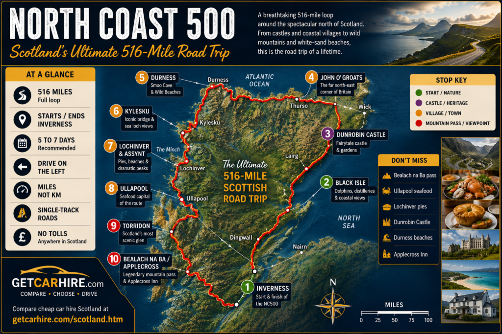
North Coast 500 route map infographic showing Scotland's iconic 516-mile circular road trip from Inverness around the far north Highlands. The satellite-style map traces the NC500 loop clockwise through Black Isle, Dunrobin Castle, John o' Groats, Durness, Kylesku, Lochinver and Assynt, Ullapool, Torridon and Bealach na Ba before returning to Inverness. The infographic includes colour-coded stop markers, a route overview panel highlighting 516 miles, 5 to 7 days, single-track roads, no tolls and left-hand driving, plus a Don't Miss guide featuring Bealach na Ba, Ullapool seafood, Lochinver pies, Dunrobin Castle, Durness beaches and the Applecross Inn.

North Coast 500 Route: The Ultimate NC500 Guide, Map & Itinerary

The North Coast 500 route is Scotland’s answer to Route 66: a 516-mile loop from Inverness around the wild far North of the Highlands, and one of the greatest road trips on Earth. Known to most simply as the NC500, it strings together surf-pounded white beaches, towering sea cliffs, fairytale castles, single-track mountain passes, ancient

North Coast 500 Route: The Ultimate NC500 Guide, Map & Itinerary Read More »

Wicklow Mountains scenic drive route map infographic showing a 120km circular driving route from Dublin through the Wicklow Mountains National Park. The map highlights 12 stops including Glencullen, Enniskerry, Powerscourt Estate, Powerscourt Waterfall, Sally Gap, Lough Tay (The Guinness Lake), Glenmacnass Waterfall, Glendalough, Laragh, Wicklow Gap and Roundwood. Key attractions include Ireland's highest waterfall, two mountain passes, Glendalough's historic round tower and the famous dark waters of Lough Tay. The infographic also includes route distances in kilometres, airport gateway information, landmark photography and a full-day driving itinerary from Dublin.

Wicklow Mountains Scenic Drive: Sally Gap, Glendalough + Best Stops

Dublin’s mountain playground: the Wicklow Mountains scenic drive over the Sally Gap and Wicklow Gap, taking in Glendalough, Lough Tay and Powerscourt. Plan your Wicklow Mountains road trip with this detailed route map showing Dublin, Powerscourt Estate, Powerscourt Waterfall, Sally Gap, Lough Tay (The Guinness Lake), Glenmacnass Waterfall, Glendalough, Laragh, Wicklow Gap and Roundwood. A

Wicklow Mountains Scenic Drive: Sally Gap, Glendalough + Best Stops Read More »

Causeway Coastal Route scenic drive map infographic showing the complete 120-mile driving route from Belfast to Derry/Londonderry along Northern Ireland's Antrim coast. The map highlights 17 major stops including Carrickfergus Castle, Glenarm, Glenariff, Carnlough, Cushendun, Torr Head, Ballycastle, Carrick-a-Rede Rope Bridge, Ballintoy, the Dark Hedges, Bushmills Distillery, Giant's Causeway, Dunluce Castle, Portrush, Portstewart, Mussenden Temple and Derry/Londonderry. The infographic includes airport gateways, route statistics, distance scale, landmark photography and driving information for one of Ireland's most scenic coastal road trips.

Causeway Coastal Route Scenic Drive: Best Stops, Places to Eat + Full Itinerary

Northern Ireland’s great coastal drive: the Causeway Coastal Route from Belfast to Derry, all castles, cliffs, the Giant’s Causeway and world-class seafood. Plan your Causeway Coastal Route road trip with this detailed route map of Northern Ireland’s Antrim coast. Discover 17 must-see stops including Carrickfergus Castle, Glenariff, Torr Head, Carrick-a-Rede rope bridge, the Giant’s Causeway,

Causeway Coastal Route Scenic Drive: Best Stops, Places to Eat + Full Itinerary Read More »

Connemara Scenic Drive: The Sky Road, Kylemore Abbey and Best Stops

Connemara Scenic Drive Mountains, bog and an island-studded coast: the classic Connemara scenic drive from Galway takes in the Sky Road, Kylemore Abbey and Ireland’s only fjord. Plan your Connemara road trip with this detailed Sky Road route map showing Galway, Oughterard, Maam Cross, the Twelve Bens, Clifden, Kylemore Abbey, Killary Fjord and Leenane. Includes

Connemara Scenic Drive: The Sky Road, Kylemore Abbey and Best Stops Read More »

Slea Head Drive: Best Stops, Map and Where to Eat on the Dingle Peninsula

Ireland’s most westerly drive: the Slea Head Drive around the Dingle Peninsula, all ancient sites, surf beaches and Atlantic drama. Plan your Dingle Peninsula road trip with this detailed Slea Head Drive route map. Discover the best stops including Ventry Beach, Dunbeg Fort, Fahan Beehive Huts, Slea Head, Coumeenoole Beach, Dunquin Pier, Gallarus Oratory and

Slea Head Drive: Best Stops, Map and Where to Eat on the Dingle Peninsula Read More »

Wild Atlantic Way Scenic Drive: Route Map, Best Stops & Itineraries | Get Car Hire

2,500km of Atlantic coast, from Donegal to Cork: the complete guide to driving the world’s longest defined coastal route. Plan your Wild Atlantic Way road trip with this detailed route map of Ireland’s west coast. Discover the five regional legs from Donegal to Cork, major attractions including Slieve League, Achill Island, Connemara, the Cliffs of

Wild Atlantic Way Scenic Drive: Route Map, Best Stops & Itineraries | Get Car Hire Read More »

Driving the Ring of Kerry: Best Stops, Map and Where to Eat

Ireland’s most famous scenic drive: 179km of mountains, coast and colourful villages around the Iveragh Peninsula. Plan your Ring of Kerry road trip with this detailed route map showing the best stops, viewpoints and attractions around the Iveragh Peninsula. Discover Killarney, Rossbeigh Beach, Cahersiveen, Waterville, Derrynane, Sneem, Kenmare, Molls Gap, Ladies View and the spectacular

Driving the Ring of Kerry: Best Stops, Map and Where to Eat Read More »

North Devon scenic drives infographic map showing five of the best coastal driving routes in North Devon, including Saunton Sands, Croyde, Woolacombe, Ilfracombe, Mortehoe, Appledore, Instow, Bideford, Clovelly and Hartland Quay. The infographic includes route distances, difficulty ratings, driving advice, the A39 Atlantic Highway and Bristol Airport as the gateway to North Devon.

5 Breathtaking North Devon Scenic Drives: Woolacombe, Clovelly and the Hartland Coast

Atlantic surf beaches, fairytale harbour villages and wild cliff-top coast roads, all reached with a hire car from Bristol. The 5 best North Devon scenic drives, all reachable with a hire car from Bristol. ⬇  Download the FREE North Devon Scenic Drives Guide (PDF) The route map, every drive at a glance, and driving tips.

5 Breathtaking North Devon Scenic Drives: Woolacombe, Clovelly and the Hartland Coast Read More »

Scroll to Top