
Wild Atlantic Way Trip Planner: Build Your Driving Itinerary
The Wild Atlantic Way runs 2,500km down Ireland’s west coast, far too much for one trip, so the art is choosing the right stretch. Our free Wild Atlantic Way trip planner and route planner builds a personalised driving itinerary in under a minute, a free alternative to poring over a static driving route map. Pick your trip length, the region you want to explore, the things you love and your pace, and the planner lays out a day-by-day route through the coast’s finest drives, complete with where to stop, what to see and where to eat. There is no sign-up and nothing to pay. Choose your options below and let the Wild Atlantic Way trip planner do the rest.
How the Wild Atlantic Way Trip Planner Works
Building your perfect Wild Atlantic Way road trip takes under a minute with our Wild Atlantic Way trip planner. Here is how.
Choose your days and region
Tell us how long you have, from 1 to 14 days, and which stretch you want, from a single region like Kerry or Connemara to the full route from Donegal to Cork.
Pick what you love
Select the things that matter most to you: coast and cliffs, mountains and passes, history and heritage, food and pubs, villages and towns, or hidden gems.
Set your pace
Choose relaxed, balanced or packed, and the planner adjusts how much it fits into each day.
Get your itinerary
Press build and your personalised day-by-day route appears in seconds, with the best stops, viewpoints and where to eat, ready to print, copy or share.
Plan your trip
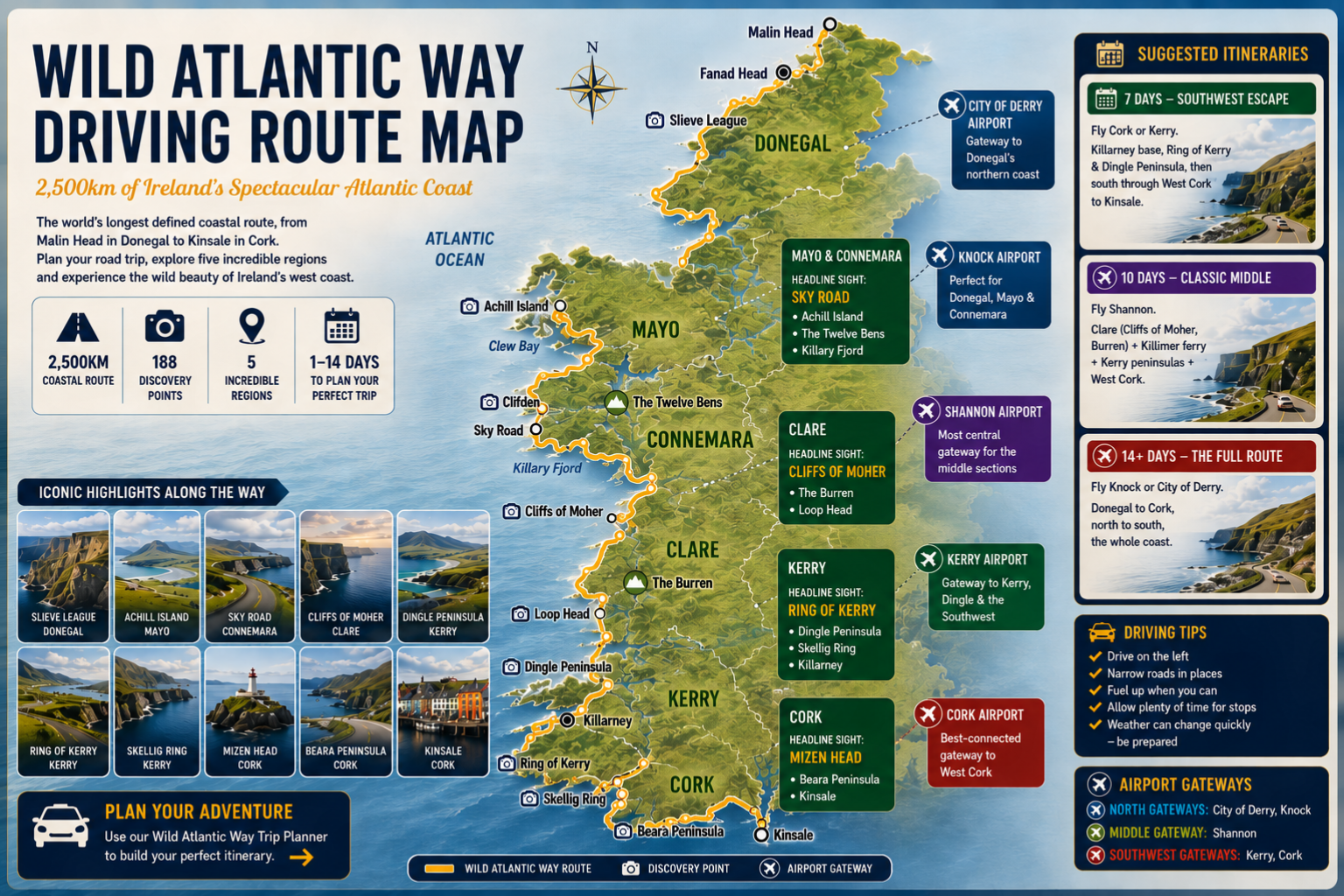
The Wild Atlantic Way Driving Route Map
The map below shows the full Wild Atlantic Way driving route from Malin Head in Donegal to Kinsale in Cork, with the five regions, the main airport gateways and the iconic stops along the way. Use it to get your bearings, then build your day-by-day plan with the Wild Atlantic Way trip planner above, part route map, part route planner in one free tool.
Why Use a Wild Atlantic Way Trip Planner?
The Wild Atlantic Way is the longest defined coastal route in the world, running 2,500km down the entire west coast of Ireland from the Inishowen Peninsula in Donegal to Kinsale in County Cork. That scale is its glory and its challenge: almost nobody has the two to three weeks it takes to drive the whole thing, so the real skill is choosing the right stretch for the time you have and linking its best drives into a route that flows.
That is exactly what this Wild Atlantic Way route planner does. Rather than trawling through dozens of separate blog posts and pinning stops onto a map yourself, you tell it your trip length, the region you want, the things you enjoy and your pace, and it assembles a sensible day-by-day itinerary in seconds. Every route in the planner is ordered north to south so the driving makes geographic sense, and each one comes with hand-picked stops, viewpoints and genuine local recommendations for where to eat, from celebrated seafood restaurants to the traditional pubs that pour the best pints along the coast.
A hire car is essential for a trip like this. Public transport along the western seaboard is sparse and infrequent, and the most spectacular viewpoints, hidden beaches and clifftop villages sit well off any bus route. With your own car you can follow the official Wild Atlantic Way signage and its 188 Discovery Points at your own pace, detour to a lighthouse on a whim, and linger over a long lunch without watching the clock. For the official route map and the full network of Discovery Points, see the official Wild Atlantic Way website.
Before you set off, it is worth brushing up on the rules of the road. Ireland drives on the left, distances on signs are in kilometres, and many of the finest coastal stretches are narrow single-lane roads with passing places, so allow far more time than the raw distance suggests and keep your speed down.
Once you have built your itinerary you can print it, copy it or share the link with your travelling companions, then compare car hire in Ireland to match your route. The Wild Atlantic Way trip planner is completely free, with no sign-up required, so feel free to build as many versions as you like until you land on the perfect Wild Atlantic Way road trip.
Wild Atlantic Way Trip Planner: Frequently Asked Questions
How many days do you need for the Wild Atlantic Way?
You can drive a single region like Kerry or Clare in a long weekend, but the full 2,500km route needs two to three weeks to enjoy properly. Most visitors choose one or two regions and spend three to seven days exploring in depth. The planner builds an itinerary for anything from one to fourteen days.
How long does it take to drive the Wild Atlantic Way?
The full Wild Atlantic Way driving route is around 2,500km (1,553 miles), and the pure driving time alone is roughly 40 to 44 hours. In practice nobody drives it in one go: allow two to three weeks for the whole coast, or three to seven days for a single region, to leave time for the stops that make the trip.
Is there a free Wild Atlantic Way route planner?
Yes. This Wild Atlantic Way route planner is completely free, with no sign-up and nothing to pay. Choose your trip length, region, interests and pace, and it builds a day-by-day driving itinerary in seconds, which you can then print, copy or share. It is designed as a free alternative to piecing a route together from a static map.
Which direction should you drive the Wild Atlantic Way?
The original and most popular direction is north to south, starting at Malin Head in Donegal and finishing in Kinsale, County Cork, which keeps you on the seaward side of the road for the best coastal views. You can drive it in reverse, and many visitors simply tackle one region, so the right direction ultimately depends on which airport you fly into and the stretch you choose.
How many counties and stages does the Wild Atlantic Way cover?
The Wild Atlantic Way passes through nine counties along Ireland’s west coast, from Donegal in the north through Leitrim, Sligo, Mayo, Galway, Clare, Limerick and Kerry to Cork in the south. The driving route is commonly divided into stages and dotted with 188 official Discovery Points, marked viewpoints with parking that make natural stops along the way.
When is the best time to drive the Wild Atlantic Way?
Late spring and early autumn, May, June and September, offer the best balance of settled weather, long daylight and quieter roads. July and August are warmest and busiest, while winter is peaceful and dramatic but with short days and some attractions closed. Whenever you go, pack for sunshine and showers in equal measure.
Which airport should I fly into for the Wild Atlantic Way?
It depends on your chosen region. Cork and Kerry airports serve the famous Southwest, Shannon is best for Clare and the middle of the route, and Knock or City of Derry suit the wild northern stretches in Donegal. Shannon is the most central choice if you want to combine several regions in one trip.
Do you need a car for the Wild Atlantic Way?
Yes. Public transport along the remote west coast is sparse and infrequent, and the most spectacular viewpoints, beaches and villages are well off any bus route. A hire car is the only practical way to follow the Wild Atlantic Way at your own pace and reach its hidden corners.
Is the Wild Atlantic Way trip planner free?
The Wild Atlantic Way trip planner is completely free with no sign-up required. Build as many itineraries as you like, then print, copy or share your plan. When you are ready, compare car hire in Ireland to match your route.
Ready to drive it? Explore our full guide to driving the Wild Atlantic Way and the Ring of Kerry, or compare car hire in Ireland to get started.