Table of Contents
5 Best Scenic Drives in Algarve (With Route Map and Driving Tips)
Most visitors to the Algarve stay within a comfortable distance of their resort and the beach. The Algarve they experience is pleasant, reliable and genuinely incomplete.
This is a region of extraordinary variety: golden limestone cliffs dropping to turquoise water on the west coast, eucalyptus and cork oak forest climbing to 902 metres in the Serra de Monchique, the perfectly preserved medieval city of Silves rising above orange groves in the interior, ancient lagoon systems teeming with birdlife along the south coast and one of the finest fishing towns in Portugal quietly going about its business in the far east.
This guide covers the 5 best scenic drives in Algarve, each one revealing a face of the region that the resort transfer bus will never show you. Every drive includes road numbers, where to stop, what to eat and the practical driving notes that make the difference.
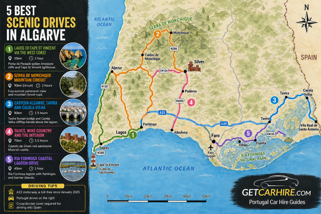
The 5 Best Scenic Drives in Algarve at a Glance
Drive 1: Lagos to Cape St Vincent via the West Coast. Lagos west on the N120 through the Costa Vicentina protected coast to Sagres, then north on the N268 to Cape St Vincent. Approximately 55 kilometres. Half day. The signature Algarve drive and one of the finest coastal routes in Europe.
Drive 2: The Serra de Monchique Mountain Circuit. Portimao (por-tee-MOW) north on the N266 through Caldas de Monchique to Monchique (mon-SHEE-keh) and Foia, then west to Aljezur (al-zheh-ZOOR) on the west coast. Approximately 90 kilometres. Full day. The Algarve’s most dramatic mountain drive.
Drive 3: The Eastern Algarve, Tavira and Cacela Velha. Faro (FAR-oh) east on the A22 or EN125 to Tavira (ta-VEE-ra), then east to Cacela Velha (ka-SEH-la VEL-ya) and Vila Real de Santo Antonio. Approximately 80 kilometres. Full day. The quietest and most historically rich part of the Algarve.
Drive 4: Silves, the Wine Country and the Interior. Albufeira (al-boo-FAY-ra) north on the EN395 to Silves (SIL-vesh), then west on the EN124 through the citrus orchards and wine estates to Monchique. Approximately 70 kilometres. Half to full day. Medieval castle, Roman heritage and the best wine in the south of Portugal.
Drive 5: The Ria Formosa Coastal Lagoon Drive. Faro east on the EN125 through the Ria Formosa Natural Park to Olhao (ol-YOW) and Fuseta (foo-ZEH-ta), then south to the barrier island ferry points. Approximately 45 kilometres. Half day. One of Europe’s most important wetland ecosystems and the best birdwatching in Portugal.
What You Need to Know Before Driving in Algarve
Portugal drives on the right. The Algarve is compact: crossing the region from the Spanish border in the east to Cape St Vincent in the west takes approximately two hours on the A22 motorway. The A22 has been toll-free since January 2025, making it the natural east-west artery. The EN125 national road runs parallel to the A22 through the resort towns and gives access to the coast and villages the motorway bypasses.
Speed limits follow standard Portuguese rules: 50 km/h in urban areas, 90 km/h on rural roads, 120 km/h on the A22. For full documentation requirements refer to the official Visit Portugal guidance for drivers.Cross-border note: Standard Portuguese rental contracts do not cover driving in Spain.
If you plan to cross the border at Vila Real de Santo Antonio to Ayamonte, confirm cross-border cover with your hire company before collecting the car. Additional insurance must be arranged in advance.
IMPORTANT: Unpaved roads and hire car insurance. Several tracks on the west coast between Carrapateira and the cliffs north of Sagres are unpaved. Standard hire car insurance does not cover damage incurred on unpaved roads. Do not drive a standard hire car on these tracks. All five drives in this guide use paved roads only. The paved coastal road from Lagos to Sagres and Cape St Vincent is fully surfaced and passable in any standard hire car.
Drive 1: Lagos to Cape St Vincent via the West Coast
Lagos to Cape St Vincent via Sagres | N120 / N268
| Start | Lagos |
| End | Cape St Vincent (Cabo de Sao Vicente) |
| Distance | Approx 55 km |
| Driving time | 1 hour without stops. Allow a half day minimum |
| Road | N120 west from Lagos to Sagres, N268 north to Cape St Vincent |
| Difficulty | Easy to moderate. Good paved road throughout. Some narrow sections near the cliffs |
The N120 west from Lagos leaves the resort coast almost immediately and enters the protected landscape of the Costa Vicentina, the longest stretch of undeveloped coastline in southern Europe. This is the Atlantic side of the Algarve, where the ocean comes straight off the open sea and the cliffs are genuinely dramatic rather than resort-dramatic.
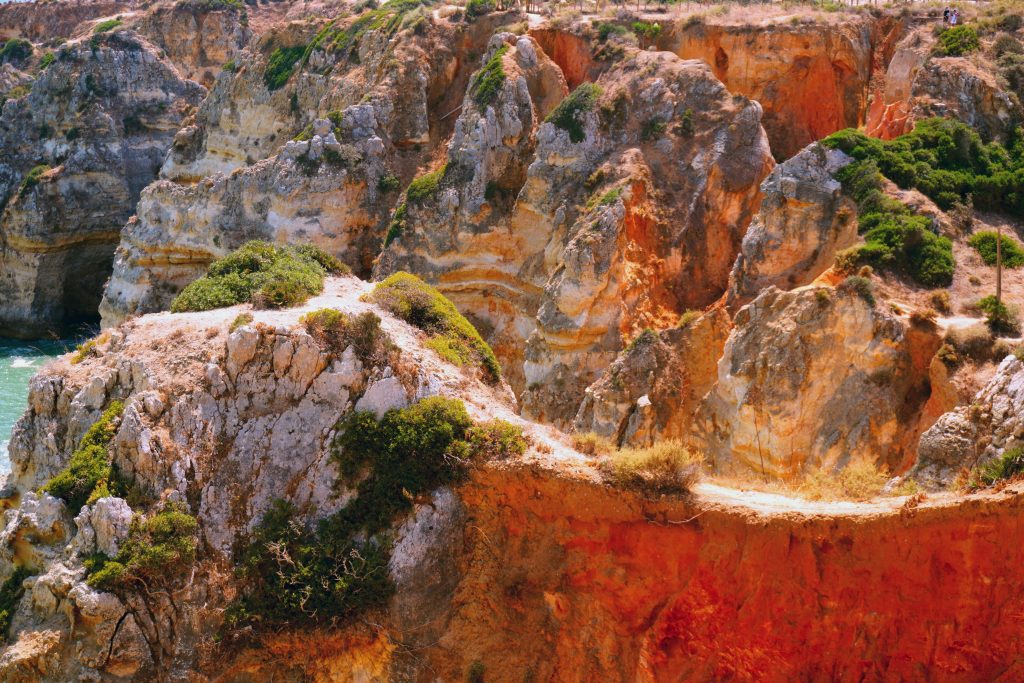
The first major stop is Ponta da Piedade (POHN-ta da PYED-ahd), the limestone rock formations just south of Lagos accessible via a short walk from the car park above. These golden arches and sea stacks rising from turquoise water are the most photographed natural feature in the Algarve and are best seen in the late afternoon when the light is warmest. Continue west on the N120 toward Sagres (SAH-gresh).
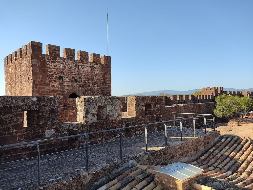
Sagres occupies a remote peninsula at the south-western tip of the Algarve. The Fortaleza de Sagres, the 15th-century fortress from which Henry the Navigator planned Portugal’s age of oceanic discovery, sits on the clifftop above the harbour.
The interior of the fortress is open to visitors and the wind-rose diagram carved into the stone courtyard is one of the most historically significant marks in European exploration. From Sagres, continue north seven kilometres on the N268 to Cape St Vincent (Cabo de Sao Vicente; KAH-boo de SOW vin-SEN-teh), the south-westernmost point of continental Europe. The lighthouse stands at the edge of 75-metre cliffs with an unobstructed view west across the open Atlantic.
Insider Tip: Drive the N120 west coast road in the late afternoon rather than the morning. The cliffs face west and the light on the limestone is at its best in the final two hours before sunset. The Fortaleza de Sagres is worth visiting early in the day before the coach groups arrive at around 11am. Combining an early fortress visit with a late afternoon cliff drive gives you both experiences at their best.
Food and Pit Stops: Drive 1
Ponta da Piedade viewpoint cafe, Lagos – coffee and light snacks at the cliff car park above the formations. Simple but well-positioned for the pre-drive start.
A Casinha, Sagres – on the main road through Sagres village. Traditional Portuguese grilled fish and bifanas (pork sandwiches; bee-FAH-naz). One of the most consistently recommended local restaurants in the western Algarve. Book ahead in summer.
O Telheiro do Infante, Sagres – on the clifftop above the harbour with unobstructed ocean views. Fresh seafood and excellent cataplana, the traditional Portuguese copper pot stew. The sunset view from the terrace is extraordinary.
Total distance: approximately 55 kilometres from Lagos to Cape St Vincent. Allow a half day with Ponta da Piedade and Sagres stops, or a full day if combining with the Fortaleza visit.
Drive 2: The Serra de Monchique Mountain Circuit
Portimao to Foia and Aljezur via the Mountain Forest | N266 / N120
| Start | Portimao |
| End | Aljezur or return circuit to Portimao |
| Distance | Approx 90 km circuit |
| Driving time | 2 hours without stops. Allow a full day |
| Road | N266 north from Portimao through Caldas de Monchique and Monchique to Foia, then west to Aljezur, N120 south on return |
| Difficulty | Moderate. N266 is a good mountain road with winding sections. Minor roads west of Foia are narrow but paved |
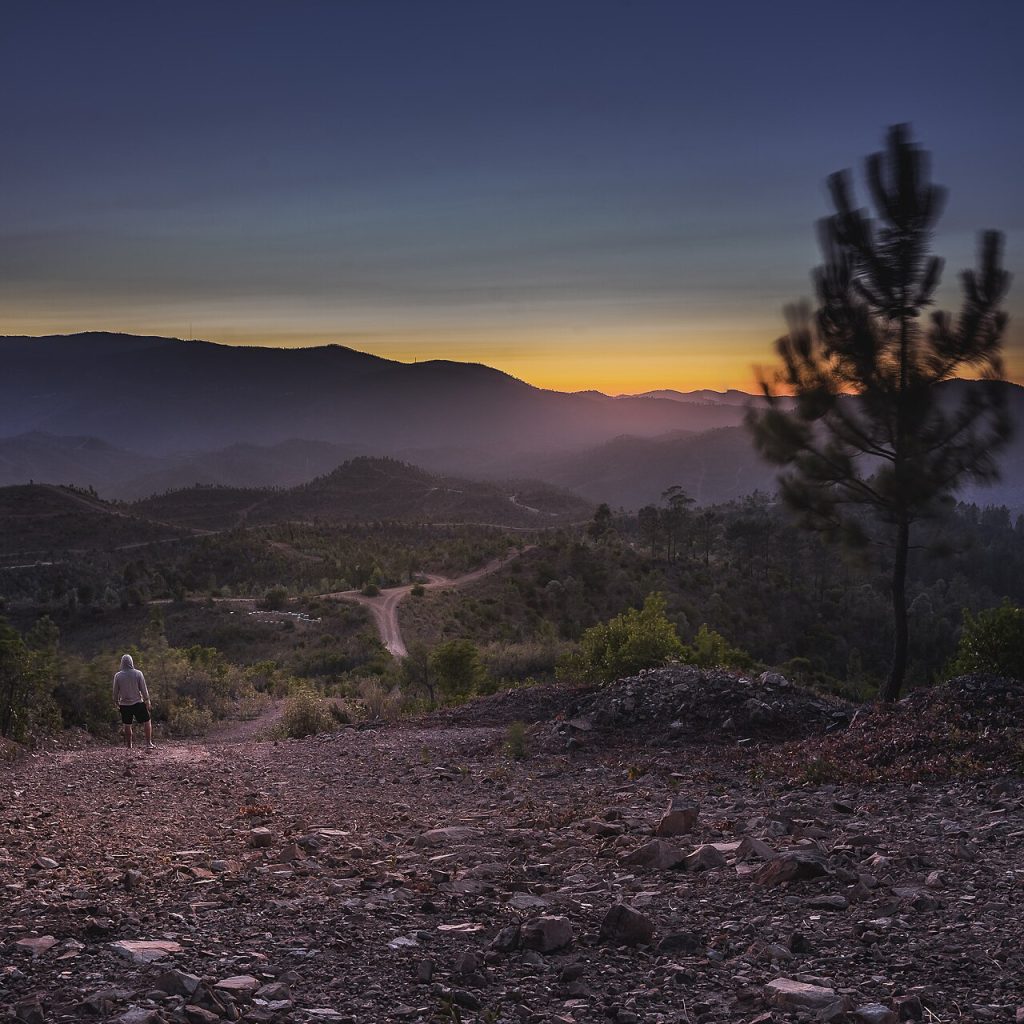
The N266 north from Portimao climbs immediately from the coastal plain into a completely different landscape. The temperature drops noticeably within the first few kilometres and the eucalyptus and medronheiro (strawberry tree; meh-droo-NYAY-roo) forest closes in on both sides of the road. This is the green Algarve that most visitors never see.
The first stop is Caldas de Monchique (KAL-dash de mon-SHEE-keh), a Victorian spa village hidden in a wooded valley where the thermal springs have been used since Roman times. The village is small, quiet and charming in a way that the coast completely lacks.
The mineral water from Caldas de Monchique is bottled and sold throughout Portugal. Continue north on the N266 to Monchique town, the most important settlement in the serra and the best place for local food and craft shopping in the mountain interior.
From Monchique take the minor road west to Foia (FOY-a), the highest point in the Algarve at 902 metres. On clear days the view from the summit stretches from Cape St Vincent in the west to the coast of Spain in the east, with the entire Algarve coast laid out below.
In winter the summit occasionally receives snow, and in summer it is 10 to 12 degrees cooler than the coast. The descent west from Foia toward Aljezur on the N267 winds through increasingly wild scenery before joining the N120 coast road.
Insider Tip: The Serra de Monchique is significantly cooler than the coast even in summer. A layer in the boot is worthwhile from October through to April. The medronho (meh-DROH-nyoo), the local arbutus berry spirit, is the regional drink of the serra and is sold at small roadside stalls throughout the mountain villages. It is powerful and excellent. The best version comes from Monchique town rather than the tourist outlets at Foia summit.
Food and Pit Stops: Drive 2
Casa Cinzas, Pocilgais – on the N266 about 15 minutes north of Portimao. Open since 1958 and a genuine institution. Cured presunto ham, local cheeses, medronho and traditional Monchique bread. The outdoor terrace under the trees is one of the most atmospheric eating spots in the Algarve interior.
Restaurante Central, Monchique – in Monchique town. Traditional mountain food: grilled chicken, pork with clams (porco com amejoas; POR-koo kom ah-MEH-zhwash) and the best arroz de pato (duck rice) in the serra. Excellent local wine list.
Cafe Foia, Foia summit – simple cafe at the summit car park. Coffee, pastries and the medronho shot that most visitors feel they have earned by the time they reach the top.Total distance: approximately 90 kilometres for the full circuit from Portimao via Foia and Aljezur returning south on the N120. Allow a full day with Caldas de Monchique, Monchique and Foia stops
Drive 3: The Eastern Algarve, Tavira and Cacela Velha
Faro to Tavira, Cacela Velha and Vila Real de Santo Antonio | A22 / EN125
| Start | Faro |
| End | Vila Real de Santo Antonio |
| Distance | Approx 80 km |
| Driving time | 1.5 hours without stops. Allow a full day |
| Road | A22 east from Faro (toll-free) to Tavira, EN125 east to Cacela Velha and Vila Real de Santo Antonio |
| Difficulty | Easy. A22 is toll-free dual carriageway. EN125 is well-maintained national road |
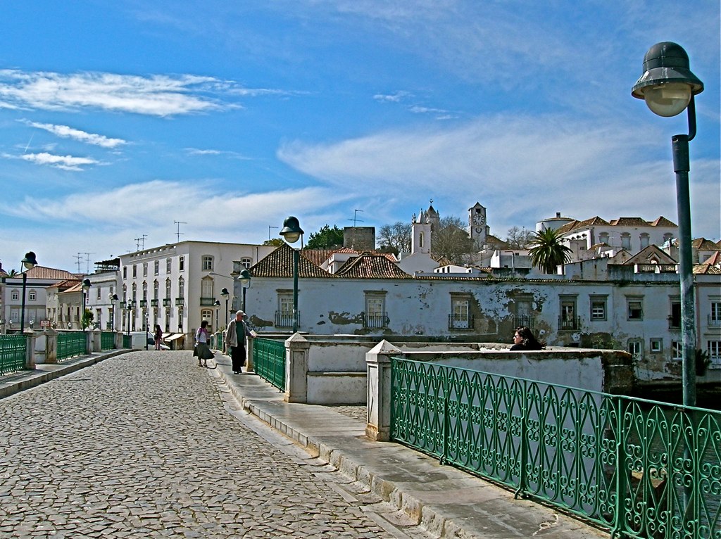
The eastern Algarve beyond Faro is the quietest and most traditionally Portuguese part of the region. The A22 runs east from Faro through flat agricultural land before the landscape opens into the wetlands and lagoons of the Ria Formosa Natural Park. The first major stop is Tavira (ta-VEE-ra), consistently rated as the most beautiful town in the Algarve and one that genuinely justifies the description.
Tavira is built on both banks of the Rio Gilao and connected by a Roman bridge and a later 17th-century span. The town has over 30 churches, a Moorish castle with views across the terracotta rooftops and a relaxed pace that the western resorts entirely lack. The fish market on the riverfront is open in the morning and the seafood restaurants clustered around it are among the finest and most reasonably priced in the Algarve.
Continue east on the EN125 to Cacela Velha (ka-SEH-la VEL-ya), a tiny whitewashed hamlet perched above the Ria Formosa lagoon that has remained almost completely unchanged for two centuries. A footpath descends to the beach and the lagoon ferry point.
The view from the village terrace across the barrier island and the Atlantic is one of the finest in the eastern Algarve. Continue east to Vila Real de Santo Antonio at the Spanish border, where a ferry crosses to Ayamonte in Spain for those with cross-border cover confirmed on their hire agreement.
Food and Pit Stops: Drive 3
Mercado da Ribeira, Tavira – the fish market on the riverfront is the best place in the eastern Algarve to understand what is fresh and local that day. The surrounding restaurants serve the market’s catch simply grilled with good bread and local wine.
Restaurante Aquasul, Tavira – on the riverfront. Excellent seafood and arroz de lingueirado (clam rice; ah-ROSH de lin-gay-RAH-doo). The terrace above the river is one of the best lunch spots in the town.
Cafe Central, Cacela Velha – the only bar in the village. Simple coffee and pasteis de nata (pastel de nata; pash-TEL de NAH-ta, Portuguese custard tarts) at a table overlooking the lagoon. Small and entirely unhurried.
Total distance: approximately 80 kilometres from Faro to Vila Real de Santo Antonio. Allow a full day with Tavira and Cacela Velha stops.
Drive 4: Silves, the Wine Country and the Interior
Albufeira to Silves and the Monchique Foothills | EN395 / EN124 / N266
| Start | Albufeira |
| End | Monchique or return via N266 to coast |
| Distance | Approx 70 km |
| Driving time | 1.5 hours without stops. Allow a half to full day |
| Road | EN395 north from Albufeira through Paderne to Silves, EN124 west through wine estates to Caldas de Monchique, N266 south |
| Difficulty | Easy to moderate. Good roads throughout. Some narrow sections in the wine estate country |
The EN395 north from Albufeira leaves the resort behind within minutes and enters a landscape of orange groves, fig orchards and low rolling hills that characterises the Algarve interior. The village of Paderne (pa-DEHR-neh), with its ruined Moorish castle above the Rio Quarteira, is worth a brief stop before continuing north to Silves (SIL-vesh).
Silves is the former Moorish capital of the Algarve and one of the most historically significant towns in Portugal. The Castelo de Silves, the best-preserved Moorish castle in Portugal, dominates the town from its hilltop position above the Rio Arade.
The red sandstone walls are extraordinary and the view from the battlements across the citrus groves to the coast is remarkable. The Museu Municipal de Arqueologia below the castle contains important Islamic artifacts from the town’s years as the regional capital before the Christian reconquest.
From Silves, the EN124 west runs through the heart of the Algarve’s emerging wine country. The region around Lagoa (la-GOH-a) and Mexilhoeira Grande (meh-shil-YWAY-ra GRAN-deh) produces some of the finest wines in southern Portugal. Several estates including Morgado do Quintao and Adega de Canena welcome visitors for tastings. Continue north on the N266 to Caldas de Monchique and connect with Drive 2 if time allows.
Silves castle is at its most dramatic in the early morning before 10am when the light is low and the tour groups have not yet arrived. The castle is elevated enough that the drive up the narrow streets from the riverfront car park is easier in a compact car than a larger vehicle. Park near the river and walk up through the old town if you have a larger hire car.
Food and Pit Stops: Drive 4
Recanto dos Mouros, Silves – below the castle walls. Traditional Algarvian cuisine with excellent cataplana and grilled fish. The courtyard setting beneath the sandstone castle walls is one of the most atmospheric restaurant settings in the Algarve.
Morgado do Quintao estate, near Portimao – wine tasting under an ancient olive tree. One of the most acclaimed producers in the Algarve region. Call ahead to arrange a tasting visit during the drive west on the EN124.
O Alcaide, Silves old town – inside the old town walls. Excellent local food and the best selection of Algarve wines by the glass in the city. Popular with local Portuguese families rather than resort visitors.
Total distance: approximately 70 kilometres from Albufeira to Monchique via Silves and the wine country. Allow a half day for Silves alone or a full day for the complete circuit.
Drive 5: The Ria Formosa Coastal Lagoon Drive
Faro to Fuseta and the Barrier Islands via the Natural Park | EN125
| Start | Faro |
| End | Fuseta and barrier island ferry points |
| Distance | Approx 45 km |
| Driving time | 1 hour without stops. Allow a half day |
| Road | EN125 east from Faro through Olhao and Fuseta along the Ria Formosa lagoon edge |
| Difficulty | Easy. EN125 is a well-maintained national road throughout |
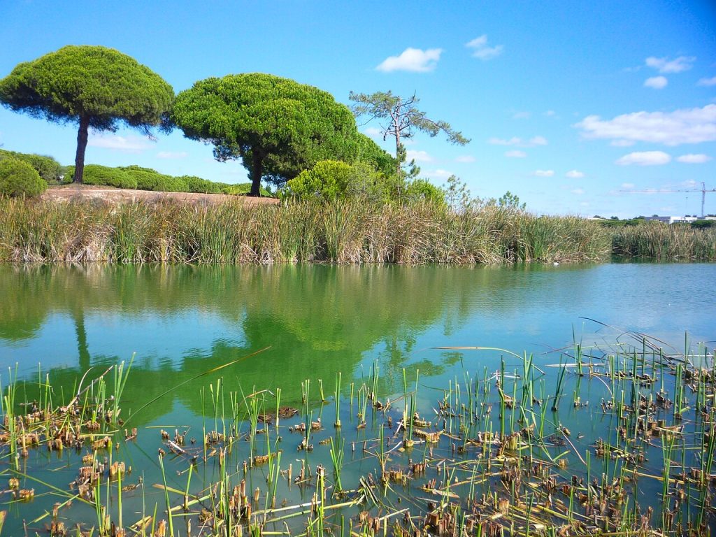
The Ria Formosa Natural Park (REE-a for-MOH-za) is one of the seven natural wonders of Portugal and one of the most important wetland ecosystems in Europe. The lagoon system stretches for 60 kilometres along the Algarve coast, covering 18,000 hectares of saltmarsh, tidal mudflat, barrier islands and open water. It provides a winter habitat for tens of thousands of migratory birds and is a year-round breeding ground for the rare purple gallinule.
The EN125 east from Faro runs along the landward edge of the lagoon, giving access to the ferry points for the barrier islands and the working fishing towns that line the coast. Olhao (ol-YOW) is the most atmospheric of these: a North African-influenced town of flat-roofed white houses and a covered market on the waterfront that is the best fish and produce market in the eastern Algarve. The market is at its most active on Saturday morning.
Continue east to Fuseta (foo-ZEH-ta), a small fishing village with a good natural lagoon beach accessible via a short ferry from the quayside. The drive along the EN125 gives frequent views across the saltmarsh to the barrier islands beyond, where the best beaches in the eastern Algarve are only accessible by the regular ferry services from Olhao and Fuseta.
Insider Tip: The Ria Formosa is best driven in the early morning for birdwatching. Flamingos are present in the shallow sections year-round and in larger numbers from October to March. The lagoon light at dawn and dusk is extraordinary and the drive east from Faro before 8am has a completely different quality to the midday version. The Olhao market is open Tuesday to Saturday morning and is the best single food shopping experience in the eastern Algarve.
Food and Pit Stops: Drive 5
Mercado de Olhao – the covered market on the Olhao waterfront is the best fish and produce market in the eastern Algarve. Open Tuesday to Saturday morning. The surrounding restaurants serve oysters, clams and fresh fish from the lagoon at tables overlooking the water.
A Tasca do Coelho, Olhao – in the old town behind the market. Family-run restaurant specialising in traditional Algarvian cataplana and grilled fish. No frills and excellent quality.
Bar do Mar, Fuseta – on the quayside above the lagoon ferry point. Simple fish and cold beer at tables above the water. The view across the lagoon to the barrier island is one of the quieter pleasures of the eastern Algarve.
Total distance: approximately 45 kilometres from Faro to Fuseta. Allow a half day with the Olhao market and ferry crossing to the barrier island.
Get Car Hire recommends comparing and booking your car hire in Algarve below.
Frequently Asked Questions
Is the Algarve good for a road trip?
Yes. The Algarve is one of the best road trip regions in Europe. The roads are well maintained, well signposted and relatively quiet outside the immediate resort areas. The A22 motorway across the region is toll-free since January 2025. The variety of landscapes from the west coast cliffs to the mountain interior to the eastern lagoons is extraordinary for a region you can cross end to end in two hours.
What is the best scenic drive in the Algarve?
The west coast road from Lagos to Cape St Vincent via Sagres is the signature Algarve drive and the one that most changes a visitor’s perception of the region. The Serra de Monchique circuit is the most dramatically scenic for landscape variety. Both are worth doing if time allows.
Is it easy to drive in the Algarve?
Yes. The main roads are straightforward and well maintained. The mountain roads in the Serra de Monchique are winding but manageable in a standard hire car at an appropriate speed. The narrow streets of Silves, Tavira and the old town of Faro warrant care but are not difficult. Portugal is generally considered one of the more relaxed driving environments in southern Europe.
Are there toll roads in the Algarve?
No. The A22 Via do Infante motorway across the Algarve has been toll-free since January 2025. Toll roads apply elsewhere in Portugal, including the A2 north toward Lisbon. If your trip extends beyond the Algarve, factor toll costs into the budget for motorway sections north of the region.
When is the best time to drive in the Algarve?
Spring from March to May and autumn from September to October offer the best combination of good driving conditions, manageable temperatures for the mountain routes and significantly lighter traffic than the peak summer months. July and August are the busiest on the coastal roads and resort towns. The drives in this guide use the quieter inland and mountain roads where traffic is lighter throughout the year.
Plan Your Algarve Road Trip
The five drives above cover an Algarve that most visitors never see. Together they take in the south-westernmost point of Europe, the highest peak in the region, the most beautiful town in Portugal, the best-preserved Moorish castle in the country and one of Europe’s most important wetland ecosystems. Each one can be completed as a standalone day out from any base in the Algarve.
For everything you need before setting off, our car hire in Algarve guide covers all pickup options at Faro Airport, booking tips and practical driving notes for the region. Transparent pricing, no hidden fees and five drives that are worth every kilometre.
About the Author
Darryl Antonio is CEO of Digitalhound, a London-based digital marketing agency with over two decades of experience in SEO and content strategy. Darryl oversees digital strategy across all sectors the agency represents and manages content production and digital strategy for Getcarhire.com.
Pingback: Car Hire in Algarve – Essential Insider Guide to Exploring Portugal's South by Car