Table of Contents
5 Best Scenic Drives in Madeira (With Route Map and Driving Tips)
Madeira has two reputations. The first is as a garden island of mild climate, levada walks and traditional embroidery. The second, known only to those who collect a hire car at the airport rather than a transfer bus, is as one of the finest driving destinations in Europe.
The ER regional roads reveal an island of extraordinary variety: a coastal road where waterfalls cascade directly over the carriageway, a glass-floored cliff platform 550 metres above the Atlantic, an ancient laurel forest that predates the last ice age emerging from a sea of cloud at 1,500 metres, a volcanic peninsula of barren ochre headlands unlike anything else in the Atlantic islands, and a mountain summit at 1,818 metres where the views on clear days extend 200 kilometres in every direction.
This guide covers the 5 best scenic drives in Madeira, each one a full or half day circuit from any base in Funchal. Every drive includes road numbers, where to stop, what to eat and the practical notes that make the difference on Madeira’s most rewarding roads.
The 5 Best Scenic Drives in Madeira at a Glance
Drive 1: The ER101 North Coast Road. Funchal north to Sao Vicente on the ER228, then west on the ER101 through waterfalls and cliffs to Porto Moniz. Approximately 85 kilometres. Full day. The signature Madeira drive and one of the most dramatic coastal roads in Europe.
Drive 2: Cabo Girao and the South Coast. Funchal west on the ER101 south coast road to Cabo Girao (Europe’s highest sea cliff at 550 metres), then west to Calheta and Ponta do Sol. Approximately 60 kilometres. Half to full day. The most vertiginous viewpoint in the Atlantic islands.
Drive 3: Paul da Serra Plateau and Fanal Forest. Funchal north on the ER228 to Encumeada Pass, then west on the ER110 across the Paul da Serra plateau at 1,500 metres to Fanal ancient laurel forest and Porto Moniz. Approximately 90 kilometres. Full day. The cloud forest and plateau circuit.
Drive 4: Ponta de Sao Lourenco Peninsula. Funchal east on the VIA1 expressway to Machico, then the ER109 to Canical and the end of the peninsula. Approximately 50 kilometres. Half day. Volcanic headlands and ocean on both sides of the narrowing peninsula.
Drive 5: Pico do Arieiro and the Laurissilva Forest. Funchal north on the ER202 to Pico do Arieiro at 1,818 metres, then down through Ribeiro Frio and the UNESCO Laurissilva forest to Faial on the north coast. Approximately 65 kilometres. Full day. The highest paved road in Madeira and the most biodiverse forest in the Atlantic islands.
What You Need to Know Before Driving in Madeira
IMPORTANT: Book an automatic car for Madeira. Manual transmission on Madeira’s steep city streets, mountain climbs and north coast roads is significantly more demanding than on most European destinations. Local hire companies recommend a minimum engine output of approximately 90hp for mountain routes. Standard compact automatics handle all five drives in this guide without difficulty.
Madeira has no toll roads. Portugal drives on the right. Speed limits: 50 km/h in towns, 80 km/h on ER regional roads and 100 km/h on the VE expressways. For all five drives below use the ER regional road routing in your navigation, not the VE expressway setting.
The expressways run through long tunnels and miss everything worth seeing. For full documentation requirements refer to Visit Portugal’s official driving guidance.
Road conditions: Madeira’s main roads are in excellent condition. Heavy rain can occasionally cause rockfalls or temporary closures on the north coast ER101. Check the Madeira Tourism road information page before any north coast drive in wet weather.
Drive 1: The ER101 North Coast Road
Funchal to Porto Moniz via Sao Vicente and the Cliff Road | ER228 / ER101
| Start | Funchal |
| End | Porto Moniz |
| Distance | Approx 85 km |
| Driving time | 2 hours without stops. Allow a full day |
| Road | ER228 north from Funchal to Sao Vicente, ER101 west along the north coast cliff road to Porto Moniz |
| Difficulty | Moderate to challenging. ER101 is narrow in sections with passing places. Drive slowly and give way to oncoming traffic. Drive west (Sao Vicente to Porto Moniz) for best visibility on bends |
The ER228 north from Funchal climbs immediately through the mountain interior, offering a series of viewpoints over the south coast and the city below. The road reaches Encumeada Pass where, on clear days, you can see both coastlines simultaneously, before descending to Sao Vicente (SOW vee-SEN-teh) on the north coast. Turn west onto the ER101 and the drive changes entirely.
The ER101 between Sao Vicente and Porto Moniz is the most extraordinary coastal road in the Atlantic islands. The road runs at the base of 600 metre cliffs with the open Atlantic on one side and sheer basalt rock face on the other. In several places waterfalls cascade directly over the carriageway. The rock is dark and dripping, the spray from the waterfall mists the windscreen and the ocean breaks against the cliff base metres below the road edge. There is nothing quite like it in Europe.
At the western end of the north coast road, Porto Moniz has natural volcanic rock pools on the seafront filled by the Atlantic swell. Swimming in the pools with the waves breaking over the outer wall is one of the defining Madeira experiences.
Insider Tip: Drive the ER101 east to west, from Sao Vicente to Porto Moniz. Going westbound puts the ocean views on your left and the cliff face on your right, which gives drivers a clearer view of the road ahead on the narrow sections. Reverse this and the driver’s sightline into the oncoming bends is more limited. Eastbound is the coach tour direction. Go west.

Food and Pit Stops: Drive 1
Restaurante Brisa Mar, Porto Moniz – on the seafront above the volcanic pools. The freshest fish on the north coast, grilled simply with good bread and local wine. The fried limpets (lapas; LAH-paz) grilled with garlic and butter are the dish that defines eating in Madeira. Book ahead in summer.
Cafe do Curral, Sao Vicente – in the village centre. Coffee and bolo de mel (BOH-loo de mel), the traditional Madeira molasses cake, before setting out west on the ER101.
Miradouro do Veu da Noiva viewpoint cafe – above Seixal beach on the ER101 westbound. Simple refreshments at the waterfall viewpoint with the best Atlantic cliff view on the north coast.
Total distance: approximately 85 kilometres from Funchal to Porto Moniz via Sao Vicente. Allow a full day with stops at Encumeada, Sao Vicente and the volcanic pools.
Drive 2: Cabo Girao and the South Coast
Funchal West to Cabo Girao, Calheta and Ponta do Sol | ER101 South
| Start | Funchal |
| End | Ponta do Sol |
| Distance | Approx 60 km |
| Driving time | 1 hour without stops. Allow a half to full day |
| Road | ER101 south coast road west from Funchal past Cabo Girao to Calheta and Ponta do Sol |
| Difficulty | Easy to moderate. South coast ER101 is well maintained. Cabo Girao access road is short and easy |
The south coast ER101 west from Funchal runs through a landscape of terraced banana plantations and clifftop villages, with the Atlantic visible between the headlands below the road. The first major destination is Cabo Girao (KAH-boo zhee-ROW), a cliff viewpoint at 550 metres that is the highest sea cliff in Europe and has a glass-floored skywalk extending over the edge.
Standing on the glass and looking straight down 550 metres to the sea and the patchwork of terraced fields below is genuinely vertiginous. Entry costs approximately €2.
Continue west to Calheta (kahl-YEH-ta), one of the few south coast towns with a sandy beach. The marina has good seafood restaurants above the water and the local rum distillery, Engenho da Calheta, offers tastings of the island’s traditional sugarcane spirit. Continue to Ponta do Sol (PON-ta do SOL), the sunniest village on the island with a dramatic seafront promenade above a pebble beach and terraced banana groves rising above the village on both sides.
Insider Tip: The Cabo Girao glass platform can become busy by mid-morning with coach tour groups. Arriving before 9.30am gives you the platform almost to yourself. The platform is genuinely dizzying even for those who are comfortable with heights, and the view down to the sea and the terraced fields below is one of the most dramatic viewpoints in the Atlantic islands.

Food and Pit Stops: Drive 2
Engenho da Calheta distillery – rum and sugarcane spirit tasting in the historic distillery. The aguardente de cana (a-gwahr-DEN-teh de KAH-na) and the poncha (POHN-sha), Madeira’s traditional mixed drink of aguardente, honey and lemon, are the spirits to try.
Restaurante Marina, Calheta – above the marina. Fresh fish and grilled meats with good views across the harbour. The espada (esh-PAH-da), black scabbardfish, is the signature fish of Madeira and found on almost every restaurant menu on the island.
Snack Bar Brisa, Ponta do Sol – on the seafront promenade. Simple food and cold drinks above the beach. The best table on the promenade is the one facing directly out to the Atlantic at sunset.
Total distance: approximately 60 kilometres from Funchal to Ponta do Sol. Allow a half day for Cabo Girao only or a full day with Calheta and Ponta do Sol.
Drive 3: Paul da Serra Plateau and Fanal Forest
Funchal to Encumeada Pass, Paul da Serra and Fanal | ER228 / ER110
| Start | Funchal |
| End | Fanal Forest and Porto Moniz |
| Distance | Approx 90 km |
| Driving time | 2 hours without stops. Allow a full day |
| Road | ER228 north from Funchal to Encumeada Pass, ER110 west across Paul da Serra plateau to Fanal and Porto Moniz |
| Difficulty | Moderate. ER228 is a good mountain road. ER110 across the plateau is straightforward but conditions change quickly at 1500m altitude. Check forecast before setting out |
The ER228 north from Funchal is the first section of Drive 1 and shares the climb to Encumeada Pass (en-koo-MYAY-da). At the pass, instead of descending to Sao Vicente, turn west onto the ER110 and the landscape shifts immediately to open moorland.
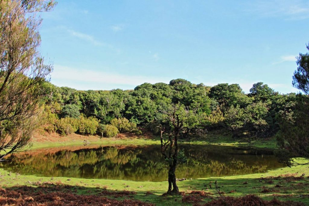
The Paul da Serra plateau (PAO-ool da SEH-ra) sits at an average altitude of 1,500 metres and is a completely different Madeira from the coastal villages below. Wind turbines turn above a rolling moorland that is frequently shrouded in cloud, with nothing visible in any direction but the plateau edge and the sky.
At the western end of the plateau, Fanal Forest is one of the most extraordinary natural landscapes in the Atlantic. The ancient Laurissilva forest a UNESCO World Heritage Site covering 15,000 hectares of Madeira, is the largest surviving fragment of the subtropical laurel forest that covered much of southern Europe before the last ice age.
At Fanal the trees are centuries old, their trunks and branches completely covered in moss and lichen, their forms emerging from the mist in ways that feel genuinely primeval. Early morning, when the cloud is low and the light filters through the canopy, is when Fanal is at its most extraordinary.
Insider Tip: Check the weather forecast specifically for the Paul da Serra plateau before setting out. The plateau can be in dense cloud and zero visibility while the south coast and Funchal are in full sunshine. A plateau drive in cloud is atmospheric but misses the panoramic views. The ideal day is one where the cloud is lifting in the morning and clearing by mid-morning. If the forecast shows total cloud on the plateau, consider doing Drive 1 or Drive 4 instead and saving this one for a clearer day.
Food and Pit Stops: Drive 3
Restaurante Encumeada, Encumeada Pass – at the pass junction. Traditional Madeira food with spectacular valley views on both sides. Caldo verde (KAL-do VEHR-de), the traditional green cabbage soup, and grilled espada are the standards. A good breakfast stop before the plateau crossing.
Cafe da Floresta, Rabaçal – a short detour south of the ER110 before Fanal. Simple food at the trailhead for the Rabaçal levada walks. The 25 Fontes waterfall walk from here takes 2 to 3 hours and is one of the finest short hikes on the island.
Porto Moniz seafront restaurants – if the circuit continues to Porto Moniz. See Drive 1 food recommendations. The volcanic pools and a late lunch make a natural endpoint for the full day circuit.
Total distance: approximately 90 kilometres from Funchal via Encumeada, Paul da Serra and Fanal to Porto Moniz. Allow a full day.
Drive 4: Ponta de Sao Lourenco Peninsula
Funchal East to the Volcanic Peninsula | VIA1 / ER109
| Start | Funchal |
| End | Ponta de Sao Lourenco peninsula car park |
| Distance | Approx 50 km |
| Driving time | 45 minutes without stops. Allow a half day including the peninsula walk |
| Road | VIA1 expressway east from Funchal to Machico junction, ER109 east through Canical to the peninsula car park |
| Difficulty | Easy. Good roads throughout. The car park at the peninsula end is the furthest point accessible by hire car. Arrive before 9am in summer – car park fills by mid-morning |
The Ponta de Sao Lourenco (PON-ta de SOW loo-REN-soo) peninsula extends east from the rest of Madeira into the open Atlantic, narrowing to a barren volcanic headland that feels completely unlike any other part of the island. Where the rest of Madeira is lush and green, the peninsula is dry, windswept and extraordinary. The ochre and red volcanic cliffs drop straight to the sea on both sides of the narrowing road.
The VIA1 expressway east from Funchal is fast and reaches Machico (ma-SHEE-koo), where the first Portuguese settlers landed in 1419, in under 20 minutes. From Machico, the ER109 continues east to Canical (ka-nee-KAL), the former whaling village, and then to the car park at the start of the peninsula walking trail.
The hire car goes no further than the car park. From here a 45 to 90 minute walk takes you to the tip of the peninsula and views east across the open Atlantic toward Porto Santo island on the horizon.
The light on Ponta de Sao Lourenco is exceptional in the early morning when the low sun catches the red and ochre volcanic rock against the blue Atlantic. Arrive before 8am for the best light and to beat the walking groups that arrive from Funchal by minibus from mid-morning.

Food and Pit Stops: Drive 4
Restaurante Mercado Velho, Machico – in the old market building in Machico old town. The best espada and grilled fish in the east of the island. Worth a stop in Machico before or after the peninsula drive.
Snack Bar Canical – in Canical village, the last town before the peninsula. Coffee, pasteis de nata and simple food before the walk. Stock up on water here as there are no facilities on the peninsula itself.
Museu da Baleia, Canical – the Whaling Museum tells the story of Madeira’s whaling history through to the last hunt in 1981. Excellent displays and genuinely moving. An hour well spent before or after the peninsula walk.
Total distance: approximately 50 kilometres from Funchal to the Sao Lourenco peninsula car park. Allow a half day with the peninsula walk and a Machico or Canical lunch stop.
Drive 5: Pico do Arieiro and the Laurissilva Forest
Funchal North to the Summit and the UNESCO Forest | ER202 / ER103
| Start | Funchal |
| End | Faial on the north coast |
| Distance | Approx 65 km |
| Driving time | 1.5 hours without stops. Allow a full day |
| Road | ER202 north from Funchal to Pico do Arieiro summit at 1818m, ER103 north through Ribeiro Frio and the Laurissilva UNESCO forest to Faial |
| Difficulty | Moderate. ER202 is a good mountain road to the summit car park. ER103 descent is winding with some narrow sections through the forest |
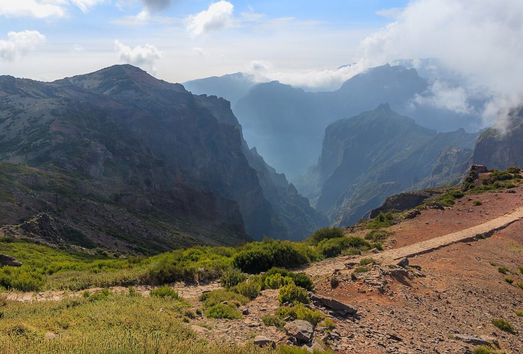
The ER202 north from Funchal climbs steadily through the island’s highest terrain to the car park at Pico do Arieiro (PEE-koo do a-ree-AY-roo) at 1,818 metres, the third highest peak in Portugal. The drive up is extraordinary in itself, with the south coast and Funchal dropping away below while the central mountain massif rises on all sides.
The summit car park has a small cafe and the views on clear days extend 200 kilometres in every direction: the island below, the Atlantic in every direction and the outline of the other Canary and Madeira island groups on the horizon.
From the summit, descend north on the ER103 through Ribeiro Frio (ree-BAY-roo FREE-oo), where the Victor’s Bar trout restaurant and the native plant garden are worth a stop, before entering the Laurissilva UNESCO World Heritage forest.
The forest at this altitude is dense, green and completely still. The levada water channels that irrigate the island run along the hillside beside the road, fed from the springs in the forest above. Continue north to Faial on the north coast, where the Penha de Aguia rock rises 590 metres directly from the sea.
Insider Tip: Pico do Arieiro at sunrise is one of the defining Madeira experiences. Funchal to the summit takes approximately 45 minutes. The light on the central peaks in the first 20 minutes after sunrise, before the cloud builds below the summit, is extraordinary. A sunrise visit requires leaving Funchal by 5am from March to October. The summit car park is free, the road is paved to the top and the cafe opens early. There is no better way to start a day in Madeira.
Food and Pit Stops: Drive 5
Cafe Pico do Arieiro, summit – at the summit car park. Simple coffee, pastries and hot soup. The only refreshments at altitude. Opens early for sunrise visitors.
Victor’s Bar, Ribeiro Frio – the most famous restaurant in the Madeira mountains. The trout, raised in the cold mountain streams, is grilled simply and is outstanding. The poncha made from local passion fruit is the drink to order.
Restaurante O Faial, Faial – on the north coast at the end of the descent. Traditional north coast seafood above the sea with views to the Penha de Aguia rock. The caldeirada de peixe and grilled limpets are the local specialities.
Total distance: approximately 65 kilometres from Funchal to Faial via Pico do Arieiro and Ribeiro Frio. Allow a full day with summit, Ribeiro Frio and Faial stops.
Find the Best Madeira Car Hire Deals for Your Island Drive
Frequently Asked Questions
Do I need a hire car in Madeira?
For Funchal itself, walking, cable cars and taxis are adequate. For any drive beyond the city, a hire car is essential. The five drives in this guide reach places that no public transport serves: the north coast waterfall road, the glass cliff platform at Cabo Girao, the plateau and laurel forest at Paul da Serra, the volcanic peninsula at Sao Lourenco and the summit at Pico do Arieiro. None are accessible without your own transport.
What is the best scenic drive in Madeira?
The ER101 north coast road between Sao Vicente and Porto Moniz is the most extraordinary road on the island and one of the most dramatic coastal drives in Europe. For those with limited time, the Pico do Arieiro summit drive delivers the most dramatic mountain scenery in under two hours from Funchal. Both are essential Madeira experiences.
Is it easy to drive in Madeira?
More demanding than most European destinations but highly rewarding with the right vehicle. The VE expressways are straightforward. The ER regional roads involve steep climbs, hairpin bends and some narrow sections on the north coast. An automatic car with adequate engine power makes a significant difference. Book an automatic before travelling and allow more time than you think you need for each route.
What time should I leave for Pico do Arieiro?
For a sunrise drive, leave Funchal by 5am from March to October. The summit car park is free, the ER202 is paved to the top and the views in the first 20 minutes after sunrise are exceptional. For a daytime visit, arriving before 9am gives you the clearest sky before cloud builds around the peaks in the late morning.
Are there toll roads in Madeira?
No. Madeira has no toll roads anywhere on the island. The VE expressways and all ER regional roads are free to use. There are no Via Verde charges, no electronic toll gates and no additional road costs beyond fuel. This is one of the significant practical advantages of driving in Madeira over mainland Portugal.
Plan Your Madeira Road Trip
The five drives above reveal the full range of what makes Madeira one of the finest driving destinations in the Atlantic. The north coast waterfall road, the highest sea cliff in Europe, an ancient forest that predates the ice age, a volcanic peninsula of barren ochre headlands and a mountain summit at nearly 1,800 metres: all of them within 90 minutes of Funchal Airport, all of them unreachable without a hire car.
For everything you need before collecting the keys, our car hire in Madeira guide covers pickup at Madeira Airport, the best operators for transparent pricing and the single most important booking tip for the island: always choose an automatic. Compare deals below and start planning your Madeira road trip.
About the Author
Darryl Antonio is CEO of Digitalhound, a London-based digital marketing agency with over two decades of experience in SEO and content strategy. Darryl oversees digital strategy across all sectors the agency represents and manages content production and digital strategy for Getcarhire.com.