Most visitors to Fuerteventura spend their entire holiday within walking distance of their resort. The beaches are excellent and the logic is understandable.
But Fuerteventura is the second largest island in the Canary Islands and the landscape beyond the resort strip is extraordinary: volcanic mountains that have barely changed since the island formed from the sea floor, ancient sand dunes that drift across a national park, a former island capital abandoned in the hills for three centuries, a sacred mountain that the island’s aboriginal people walked barefoot across an ocean to visit, and a wild southern peninsula that ends at a lighthouse with Africa visible on the horizon on clear days.
This guide covers the 5 best scenic drives in Fuerteventura, each one revealing a different face of an island most visitors never see. Every drive includes road numbers, where to stop, what to eat and practical driving notes.
Table of Contents
The 5 Best Scenic Drives in Fuerteventura at a Glance
Drive 1: The Corralejo Dunes and El Cotillo Northern Circuit. Corralejo south through the natural park dunes on the FV-1, then west to El Cotillo via Lajares on the FV-101. Approximately 45 kilometres. Half day. Sunset at El Cotillo is among the finest in the Canary Islands.
Drive 2: The FV-30 Betancuria Mountain Road. Pajara north through Vega de Rio Palmas and the Betancuria Natural Park to the ancient capital of Betancuria (beh-tan-KOO-ree-ah), then on to Mirador de Morro Velosa. Approximately 55 kilometres. Full day. One of the most dramatic mountain roads in the Atlantic islands.
Drive 3: The Jandia Peninsula Lighthouse Drive. Morro Jable (MO-roh HA-bleh) south to the Faro de Punta Jandia lighthouse on the paved coastal road. Approximately 40 kilometres return. Half day. Important: the final section is unpaved and not covered by standard hire car insurance.
Drive 4: The Eastern Coast and Entallada Lighthouse Route. Caleta de Fuste south via the FV-2 to Gran Tarajal, then east on the FV-512 to Las Playitas and the Faro de Entallada, the closest point on the island to the coast of Africa. Approximately 50 kilometres. Half day.
Drive 5: The Tindaya Sacred Mountain and La Oliva Interior Circuit. Puerto del Rosario north-west via the FV-207 to Tindaya (tin-DAH-yah) sacred mountain, then north through La Oliva (la oh-LEE-vah) to Los Molinos fishing village and back south. Approximately 60 kilometres. Full day.
What You Need to Know Before Driving in Fuerteventura
Spain drives on the right. Fuerteventura is the second largest of the Canary Islands, approximately 100 kilometres long from north to south. The two main roads are the FV-1 running from Puerto del Rosario north to Corralejo (koh-rah-LEH-ho), and the FV-2 running south from Puerto del Rosario all the way to Morro Jable on the Jandia peninsula.
Both are dual carriageway in the northern and central sections and carry fast-moving traffic. All five drives in this guide branch from these main arteries onto the quieter secondary roads where the island’s character is found.
Speed limits follow the standard Spanish framework: 50 km/h in towns, 90 km/h on rural roads, 100 km/h on the FV-1 and FV-2 dual carriageways. For full documentation requirements refer to the official DGT guidance for drivers in Spain.
Wind: Fuerteventura is one of the windiest places in Europe and the Atlantic trades can be strong enough on exposed roads to affect steering, particularly on a high-sided vehicle. Drive with both hands on the wheel on the coastal roads and the Jandia peninsula.
WARNING: Unpaved roads and hire car insurance. Standard hire car insurance in Fuerteventura does NOT cover damage incurred on unpaved roads. The road to Cofete Beach beyond the Jandia lighthouse, and several tracks leading to remote beaches, are unpaved. If you drive on these roads and damage the car, you will be personally liable for all costs. Drive 3 in this guide routes you along the paved coastal road only.
Drive 1: The Corralejo Dunes and El Cotillo Northern Circuit
Corralejo to El Cotillo via the Sand Dunes and Lajares | FV-1 / FV-101
| Start | Corralejo |
| End | El Cotillo |
| Distance | Approx 45 km |
| Driving time | 1 hour without stops. Allow a half day |
| Road | FV-1 south through Corralejo Natural Park dunes, FV-101 west through Lajares to El Cotillo |
| Difficulty | Easy. Good roads throughout. FV-1 through dunes is dual carriageway |
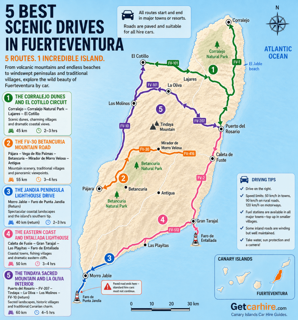
The FV-1 south from Corralejo passes through the Corralejo Natural Park, an extraordinary landscape of rolling sand dunes that drift across the northern peninsula directly onto white Atlantic beaches.
The dunes reach up to 30 metres in height and the road cuts through them in a straight line with the sea visible to both east and west at the same time. This is one of the most visually striking short drives in the Canary Islands.
There are authorised car parks at intervals along the dune section. Stop at the first one heading south, walk 10 minutes across the dunes to the beach and return. The sand is fine and pale and the water is transparent. In the morning before 9am the beaches here are empty regardless of the season.
From the southern end of the dune park, leave the FV-1 and take the FV-101 west toward Lajares (la-HA-res), a small village that has become a quiet centre for the island’s surf and yoga community. The village square has good coffee and the Saturday craft market is worth stopping for if visiting at the weekend.
Continue west to El Cotillo (koh-TEE-yoh), a former fishing village on the northwest coast with a 17th-century watchtower, a small harbour, natural tidal swimming pools to the south and some of the best sunset views on the island.
Insider Tip: Drive the FV-1 dune section before 9am on any day of the week. The dune car parks fill by 10am from May to September and the approach road slows significantly. Early morning, the light on the sand is extraordinary and the beaches beyond the dunes are empty. El Cotillo faces West and catches the last light of the day beautifully from the clifftop above the harbour. Combining an early dune start with a sunset finish at El Cotillo makes this the best value half-day on the island.
Food and Pit Stops: Drive 1
La Marquesina, Corralejo harbour – fresh fish restaurant on the waterfront. The cherne (deep sea grouper) and the local octopus are the dishes to order. Excellent base for breakfast before the early dune drive.
La Creperie de Lajares – in the village square. The most consistently recommended food stop in the northern interior. Excellent coffee and the sweet and savoury crepes are worth the short detour.
El Goloso, El Cotillo – above the natural pools to the south of the village. Excellent fresh fish and local Canarian dishes. The terrace faces directly west over the Atlantic. One of the better sunset dining spots on the island.
Total distance: approximately 45 kilometres from Corralejo to El Cotillo. Allow a half day with dune stops and El Cotillo exploration.
Drive 2: The FV-30 Betancuria Mountain Road
Pajara to Betancuria and Mirador de Morro Velosa via the Natural Park | FV-30 / FV-416
| Start | Pajara |
| End | Antigua via FV-416 |
| Distance | Approx 55 km |
| Driving time | 1.5 hours without stops. Allow a full day |
| Road | FV-30 north through Vega de Rio Palmas and Betancuria Natural Park to Mirador de Morro Velosa, FV-416 east to Antigua |
| Difficulty | Moderate to challenging. Narrow with hairpin bends and steep drops in sections. Drive slowly and give way to oncoming traffic |
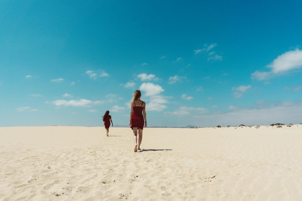
The FV-30 is the most dramatic road on the island and one of the most spectacular mountain drives in the entire Canary Islands. It climbs north from Pajara (PAH-ha-rah) through the Betancuria Natural Park, a landscape of eroded volcanic ridges, dry valleys and ancient lava fields that is entirely unlike the flat coastal plains most visitors see from the resort.
The road winds through Vega de Rio Palmas (BEH-ga de REE-oh PAL-mas), a small valley with a famous chapel and a cluster of Canarian pines that makes it one of the greenest spots on the island.
Continue north through the increasingly dramatic landscape to Betancuria itself, the former capital of Fuerteventura, founded in 1404 and one of the oldest European settlements in the Canary Islands. The town was deliberately built inland to protect it from pirate raids. The 17th-century church, the archaeological museum and the handsome main square make it the most historically interesting stop on the island.
North of Betancuria, the FV-30 climbs to the Mirador de Morro Velosa, a viewpoint and visitor centre designed by Cesar Manrique that offers the finest panoramic view on Fuerteventura: the whole northern half of the island spread below, with the Corralejo dunes visible on the horizon on clear days. The two giant statues of the Guanche kings Ayoze and Guize at the roadside below the mirador are an unmissable landmark.
Insider Tip: Drive the FV-30 South to North, Pajara to Betancuria, rather than the reverse. Ascending from the south, the blind hairpin bends have the rock face on your right and the drop on your left. Descending south puts the drop directly in the driver’s eye-line on the tightest corners. Locals always drive it North. Start early to have Betancuria to yourself before the day trip coaches arrive at around 11am.

Food and Pit Stops: Drive 2
Bar La Fuentita, Vega de Rio Palmas – traditional Canarian bar in the valley below the chapel. Coffee and local pastries served at tables on the terrace. Simple and excellent.
Restaurante Don Antonio, Betancuria – the most consistently recommended restaurant in the island’s interior. Serves traditional Canarian food including rabbit stew, puchero (a slow-cooked meat and vegetable stew; pronounced poo-CHEH-roh) and fresh papas arrugadas with mojo sauce. The courtyard terrace is one of the pleasantest places to eat on the island.
Mirador de Morro Velosa cafe – the visitor centre at the top serves coffee and cold drinks with the panoramic view. Worth stopping for the views even if you do not eat.
Total distance: approximately 55 kilometres from Pajara to Antigua. Allow a full day with Betancuria and the Mirador stop.
Drive 3: The Jandia Peninsula Lighthouse Drive
Morro Jable to Faro de Punta Jandia via the Paved Coastal Road | FV-2 Extension
| Start | Morro Jable |
| End | Faro de Punta Jandia (paved section only) |
| Distance | Approx 40 km return |
| Driving time | 1 hour return without stops. Allow a half day |
| Road | FV-2 extension south-west from Morro Jable along the Jandia paved coastal road |
| Difficulty | Easy on paved road. Standard hire cars must not continue beyond the paved section – insurance is void on unpaved tracks |
HIRE CAR INSURANCE WARNING: The paved road ends approximately 8 kilometres before Faro de Punta Jandia. The final section to the lighthouse is an unpaved track. Standard hire car insurance explicitly excludes damage on unpaved roads. Do not drive a standard hire car on the unpaved section. The viewpoint from the top of the paved road above the lighthouse is visible and the coastal views are fully rewarding without continuing further.
The Jandia peninsula occupies the southern third of Fuerteventura and is separated from the rest of the island by the narrow isthmus of La Pared, where the original Guanche wall that divided the island into two kingdoms once stood.
The FV-2 south from Morro Jable follows the western coast of the peninsula through a landscape of increasing remoteness: black volcanic cliffs dropping to surf beaches, the mountains of the Jandia Natural Park rising sharply inland and almost no human presence of any kind.
Playa de Sotavento, approximately 15 kilometres south of Morro Jable, is one of the finest beaches in the Canary Islands. A natural tidal lagoon forms at high tide and the long straight beach is a world-famous kite-surfing location. The lagoon is best seen from the clifftop road above rather than from the beach itself.
Continue south to Puerto de la Cruz (PWER-toh de la KROOS), a tiny coastal settlement with a small harbour and two excellent beach restaurants. The road continues south-west toward the lighthouse. The paved section ends with a viewpoint above the coast and a view of the lighthouse and the cliffs of the southern tip with Africa visible on clear days across the water.
Insider Tip: The Western coast of the Jandia peninsula faces north-west and catches the Atlantic swell directly, making Playa de Sotavento and the beaches around it excellent for watching kite surfers but not always comfortable for swimming. The calmer swimming beaches are on the Eastern side of the peninsula around Playa de Matas Blancas and Playa de Esquinzo, accessible from the FV-2 before Morro Jable. If combining Drive 3 with a beach day, start on the western drive in the morning and return to the calmer Eastern beaches in the afternoon.

Food and Pit Stops: Drive 2
Bar La Fuentita, Vega de Rio Palmas – traditional Canarian bar in the valley below the chapel. Coffee and local pastries served at tables on the terrace. Simple and excellent.
Restaurante Don Antonio, Betancuria – the most consistently recommended restaurant in the island’s interior. Serves traditional Canarian food including rabbit stew, puchero (a slow-cooked meat and vegetable stew; pronounced poo-CHEH-roh) and fresh papas arrugadas with mojo sauce. The courtyard terrace is one of the pleasantest places to eat on the island.
Mirador de Morro Velosa cafe – the visitor centre at the top serves coffee and cold drinks with the panoramic view. Worth stopping for the views even if you do not eat.
Total distance: approximately 55 kilometres from Pajara to Antigua. Allow a full day with Betancuria and the Mirador stop.
Drive 4: The Eastern Coast and Entallada Lighthouse Route
Caleta de Fuste to Las Playitas and the Closest Point to Africa | FV-2 / FV-512
| Start | Caleta de Fuste |
| End | Faro de Entallada |
| Distance | Approx 50 km |
| Driving time | 1 hour without stops. Allow a half day |
| Road | FV-2 south to Gran Tarajal, FV-512 east to Las Playitas and the lighthouse road |
| Difficulty | Easy to moderate. Narrow winding road on the final climb to the lighthouse |
The eastern coast of Fuerteventura between Caleta de Fuste and Gran Tarajal is the quietest and most local stretch of coastline on the island. The FV-2 south from Caleta de Fuste runs inland through the agricultural centre of the island before returning to the coast at Gran Tarajal (gran ta-ra-HAL), the second town on the island and the one most visitors never see.
Gran Tarajal has a long seafront promenade, good fish restaurants and a black sand beach that is a complete contrast to the white sands of the resort coast.
From Gran Tarajal, the FV-512 east winds through the volcanic hills to Las Playitas, a traditional fishing village that is worth exploring for the harbour, the village atmosphere and the small black sand beach.
From Las Playitas the road climbs steeply to the Faro de Entallada, a lighthouse perched on a clifftop that is the nearest point on Fuerteventura to the African continent.
On clear days the outline of the Atlas Mountains of southern Morocco is visible across the water. The road to the lighthouse is one of the most dramatic short ascents on the island.
Insider Tip: The Faro de Entallada road is one-way at the top with a small car park and turning area at the lighthouse. Arrive before 11am to have the clifftop to yourself. On days when the calima is absent, the visibility east across the Atlantic to Africa is remarkable and best captured in the morning light. The ‘Calima’ is a haze of Saharan dust carried west by the trade winds that reduces visibility significantly, particularly in late summer. Check the sky condition before making the lighthouse the centrepiece of the day.
Food and Pit Stops: Drive 4
Restaurante El Sotillo, Gran Tarajal – on the seafront promenade. One of the best fish restaurants on the island, entirely off the tourist trail. The local clams (almejas; al-MEH-has) and the grilled fish of the day are excellent.
Bar El Puertito, Las Playitas – the village bar at the fishing harbour. Simple Canarian food and good coffee at tables overlooking the harbour wall.
Caleta de Fuste beachfront on the return – the resort itself has a calm lagoon beach and a selection of restaurants for the return leg.
Total distance: approximately 50 kilometres from Caleta de Fuste to the Entallada lighthouse. Allow a half day with Gran Tarajal and Las Playitas stops.
Drive 5: The Tindaya Sacred Mountain and La Oliva Interior Circuit
Puerto del Rosario to Tindaya, La Oliva and Los Molinos | FV-207 / FV-101 / FV-10
| Start | Puerto del Rosario |
| End | Los Molinos |
| Distance | Approx 60 km |
| Driving time | 1.5 hours without stops. Allow a full day |
| Road | FV-207 north-west to Tindaya, FV-101 north to La Oliva, minor road west to Los Molinos, FV-10 south on return |
| Difficulty | Easy. Good roads throughout |
The northern interior of Fuerteventura is one of the least visited parts of the island and one of the most rewarding. The FV-207 north-west from Puerto del Rosario (PWER-toh del roh-SAR-ee-oh) passes through a succession of small agricultural villages set against the bare volcanic ridges of the central spine.
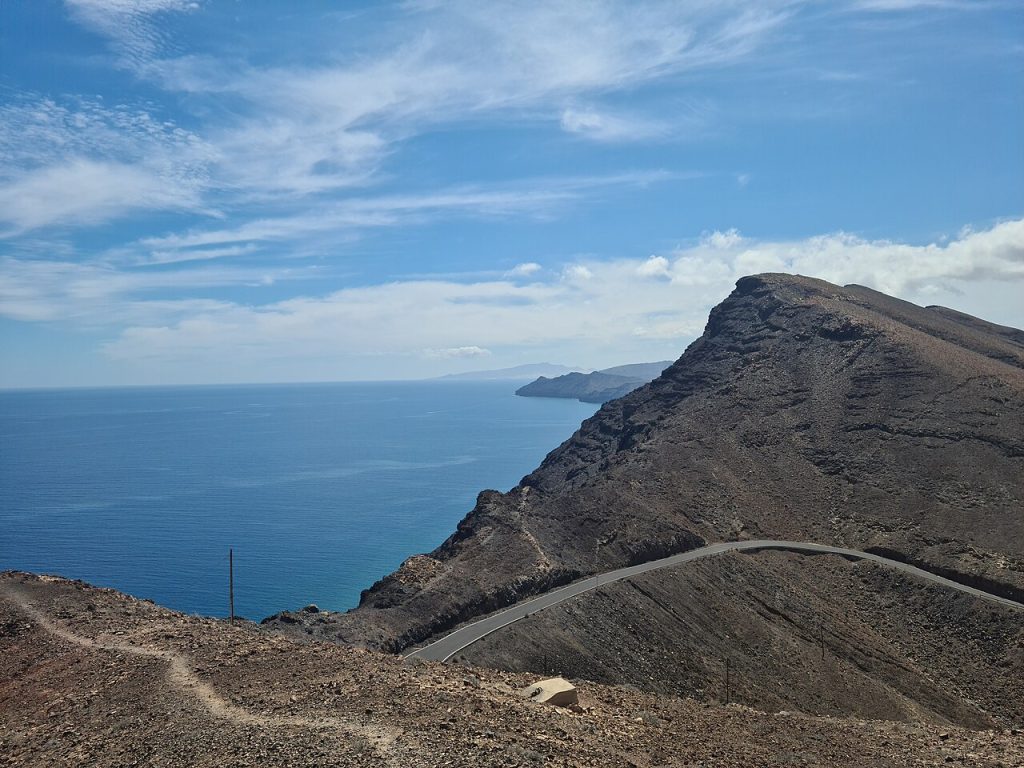
The first major stop is Tindaya (tin-DAH-yah), a mountain of phonolite rock rising 401 metres from the plain that was the most sacred site of the island’s Guanche people, the Mahos. The Mahos walked barefoot to Tindaya from across the island to make offerings at the summit. The mountain is covered in ancient podomorphs, foot-shaped engravings carved into the rock, and is protected as a UNESCO-recommended site. Climbing is prohibited.
Continue north on the FV-101 to La Oliva (la oh-LEE-vah), one of the finest village squares on the island. The Church of Our Lady of La Candelaria has a distinctive black stone bell tower that is one of the most photographed buildings in Fuerteventura. The Casa de los Coroneles, the imposing former residence of the island’s military governors, stands opposite and is open as a cultural centre.
Take the minor road west from La Oliva to Los Molinos (los mo-LEE-nos), a tiny fishing village on the northwest coast with a handful of houses, a small beach and a bar serving fresh fish. The contrast between this and any resort on the island is complete.
Insider Tip: Tindaya mountain is a site of genuine spiritual significance to the Canarian indigenous heritage and must be treated accordingly. Do not attempt to climb the mountain and do not touch or photograph the podomorph carvings at close range. The best time to see the mountain is late afternoon when the light catches the ochre and grey rock at its most dramatic. The Mirador de Vallebron (va-yeh-BRON), a viewpoint 3 kilometres north on the FV-207, offers the finest distant view of the mountain in context with the northern plain.
Food and Pit Stops: Drive 5
Casa Marcos, La Oliva – traditional Canarian restaurant on the village square. The goat stew, puchero canario and fresh fish are all excellent. One of the most authentic dining experiences in the northern interior.
Bar Los Molinos, Los Molinos – the only bar in the fishing village serves fresh grilled fish and the local beer. Eating at a table above the beach with the north coast in front of you is one of the more quietly satisfying moments available on the island.
Tetir village bakery – on the FV-207 en route from Puerto del Rosario. Traditional Canarian bread and pastries including the local bienmesabe (beeyen-meh-SAH-beh) almond cream.
Total distance: approximately 60 kilometres from Puerto del Rosario to Los Molinos. Allow a full day with Tindaya, La Oliva and Los Molinos stops.
Fuerteventura UNESCO Biosphere Reserve
The entire island of Fuerteventura was designated a UNESCO Biosphere Reserve in 2009, recognising the exceptional volcanic landscape, the ancient dune systems of the Corralejo Natural Park and the endemic plant and animal species of the Jandia Natural Park. The designation covers 163,000 hectares including the marine area and underpins the island’s approach to sustainable tourism.
Get Car Hire recommends comparing and booking your car hire in Fuerteventura below.
Frequently Asked Questions
Is it easy to drive in Fuerteventura?
Yes. The main FV-1 and FV-2 roads are dual carriageway and straightforward. The secondary roads are well-maintained and clearly signposted. The FV-30 mountain road requires care due to narrow sections and hairpin bends but is manageable in a standard compact hire car if you drive slowly. The only roads to avoid in a standard hire car are unpaved tracks, which are not covered by insurance.
Can you drive to Cofete Beach in a hire car?
Not safely or legally in a standard hire car. The road to Cofete Beach from the Jandia lighthouse is unpaved and standard hire car insurance explicitly excludes damage on unpaved roads. You would be personally liable for any damage. Cofete is accessible by 4×4 with specialist all-terrain insurance, by the occasional taxi that serves the route, or on foot from the paved road above.
What is the best scenic drive in Fuerteventura?
The FV-30 Betancuria mountain road is the most dramatically scenic single drive on the island and the one that most changes a visitor’s perception of Fuerteventura. The Corralejo dunes circuit is the most visually striking for those staying in the north. Both are worth doing if time allows.
When is the best time to drive in Fuerteventura?
Fuerteventura has excellent driving conditions year-round with rarely any rain. The summer months of July and August bring the strongest trade winds and occasional calima dust haze that reduces visibility. Spring from March to May and autumn from September to November offer the best combination of good light, manageable wind and quieter roads.
Do I need a hire car in Fuerteventura?
A hire car is the only practical means of seeing anything beyond the resort perimeter. Public buses connect the main resorts and Puerto del Rosario but do not serve the Betancuria interior, the Jandia peninsula lighthouse road, Tindaya, La Oliva, Los Molinos or any of the drives in this guide. For the island as a whole, a hire car is essential.
Plan Your Fuerteventura Road Trip
The five drives above cover an island that is almost entirely invisible from the resort perimeter. The ancient mountain capital, the sacred volcano of the Guanche people, the lighthouse at the edge of Africa, the dunes that shift across a national park and the quiet fishing villages that the package holiday industry never found: all of them are within a comfortable drive of any resort on the island.
For everything you need before setting off, our car hire in Fuerteventura guide covers all pickup locations at Fuerteventura Airport, pricing and booking. Transparent pricing, no hidden fees and five drives genuinely worth making.
For a completely different Canary Islands driving experience, explore our scenic drives guide for Gran Canaria.
About the Author
Darryl Antonio is CEO of Digitalhound, a London-based digital marketing agency with over two decades of experience in SEO and content strategy. Darryl oversees digital strategy across all sectors the agency represents and manages content production and digital strategy for Getcarhire.com.
Pingback: Car Hire in Fuerteventura – Must-Have Insider Guide to Exploring the Island by Car