Most visitors to Gran Canaria spend their time along the southern coast between Maspalomas and Puerto Rico. A hire car and a morning heading inland reveals a completely different island: sharp volcanic peaks, ancient ravines, pine forests above the clouds and whitewashed mountain villages that have barely changed in centuries.
This guide covers the 5 best scenic drives in Gran Canaria, each one taking you through landscapes as varied as any in southern Europe. Every drive includes the best places to stop, eat and what to order when you get there.
Table of Contents
The 5 Best Scenic Drives in Gran Canaria at a Glance
Drive 1: The GC-60 Mountain Drive. Maspalomas to Tejeda via Fataga and Roque Nublo. Approximately 65 kilometres. Full day. Lunch stop at Tejeda or Parador Cruz de Tejeda.
Drive 2: The Barranco de Guayadeque. Gran Canaria’s ancient cave ravine. Approximately 9 kilometres into the ravine from Aguimes. Half day. Lunch at Restaurante Vega, a second-generation cave restaurant carved into the ravine wall.
Drive 3: The West Coast GC-200. Mogan to La Aldea de San Nicolas via Mirador del Balcon. Approximately 50 kilometres. Full day. Start with breakfast on the Puerto de Mogan harbour before heading north.
Drive 4: The Agaete Valley and North Coast Loop. Las Palmas to Puerto de las Nieves and the Valle de Agaete. Approximately 70 kilometres. Full day. Lunch at Casa Romantica, Michelin Guide listed, in the heart of the Agaete coffee valley.
Drive 5: The Cruz de Tejeda Ridge Route. Pico de las Nieves to Teror via Cruz de Tejeda and Artenara. Approximately 45 kilometres. Full day. Stop at the Parador Cruz de Tejeda restaurant for a traditional Canarian lunch at the island’s mountain crossroads.
What You Need to Know Before Driving in Gran Canaria
Spain drives on the right. Road signs appear in both Spanish and Castilian throughout Gran Canaria. Speed limits follow the standard framework set by the Direccion General de Trafico, Spain’s national road traffic authority: 50 km/h in towns and villages, 90 km/h on open rural roads, 120 km/h on the GC-1 motorway between Las Palmas and Maspalomas. There are no toll roads on Gran Canaria.
Petrol stations are concentrated in Las Palmas, Maspalomas and the larger resort towns along the southern coast. The central mountain interior has very few stations between the GC-1 motorway and the mountain endpoints.
Fill the tank before setting off on Drives 1, 3 and 5 in particular. For the full legal requirements for driving in Spain, including documentation and equipment rules, refer to the official DGT guidance for drivers in Spain.
Cyclists are a major presence on Gran Canaria’s mountain roads year round. The island is a popular winter training destination for professional cycling teams. Give them wide clearance on the GC-60 and the roads around Roque Nublo in particular.
Drive 1: The GC-60 Mountain Drive
Maspalomas to Tejeda via Fataga and Roque Nublo | GC-60 / GC-600
| Start | Maspalomas |
| End | Tejeda |
| Distance | Approx 65 km one way |
| Driving time | 2 to 3 hours without stops. Allow a full day with stops |
| Road | GC-60 north from Maspalomas, then GC-600 to Roque Nublo |
| Difficulty | Moderate. Winding mountain road with good surfaces and guardrails throughout |
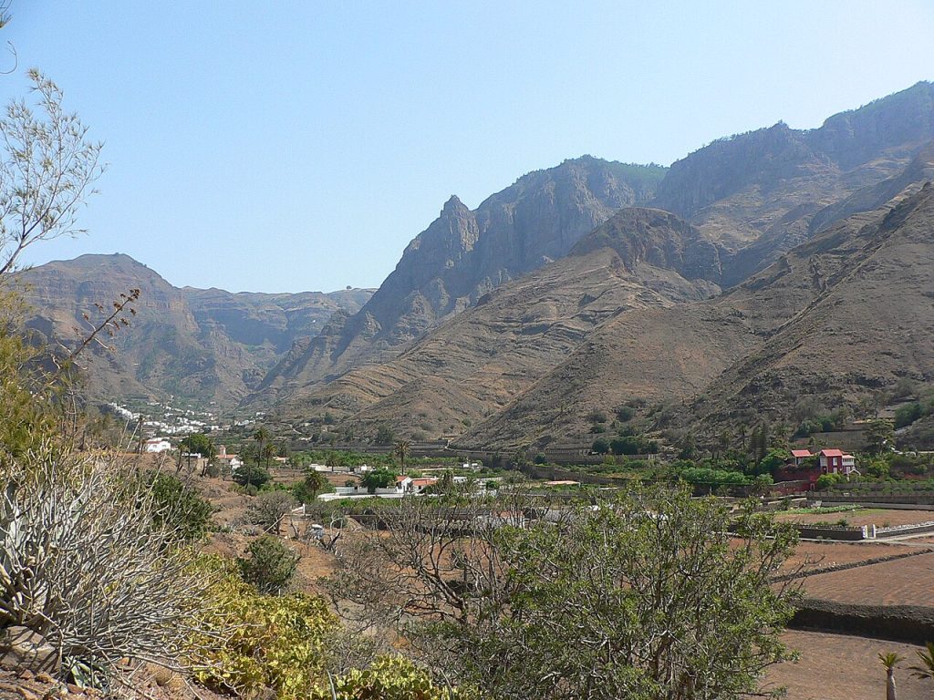
This is the classic Gran Canaria drive and the one most worth prioritising. From Maspalomas the GC-60 climbs steadily northward into the island’s interior, shedding the coastal resort atmosphere within minutes.
The road is immediately dramatic, rising through the Barranco de Fataga, a deep ravine of ochre volcanic rock and ancient palm groves. Fataga village sits on a ridge overlooking the ravine and is worth a short stop: the white houses and narrow streets feel a world away from Playa del Ingles thirty minutes below.
Continue north on the GC-60 through San Bartolome de Tirajana, the quiet capital of the island’s most visited municipality. Locals and very few tourists stop here for coffee and papas arrugadas with mojo sauce at the terrace cafes on the main square.
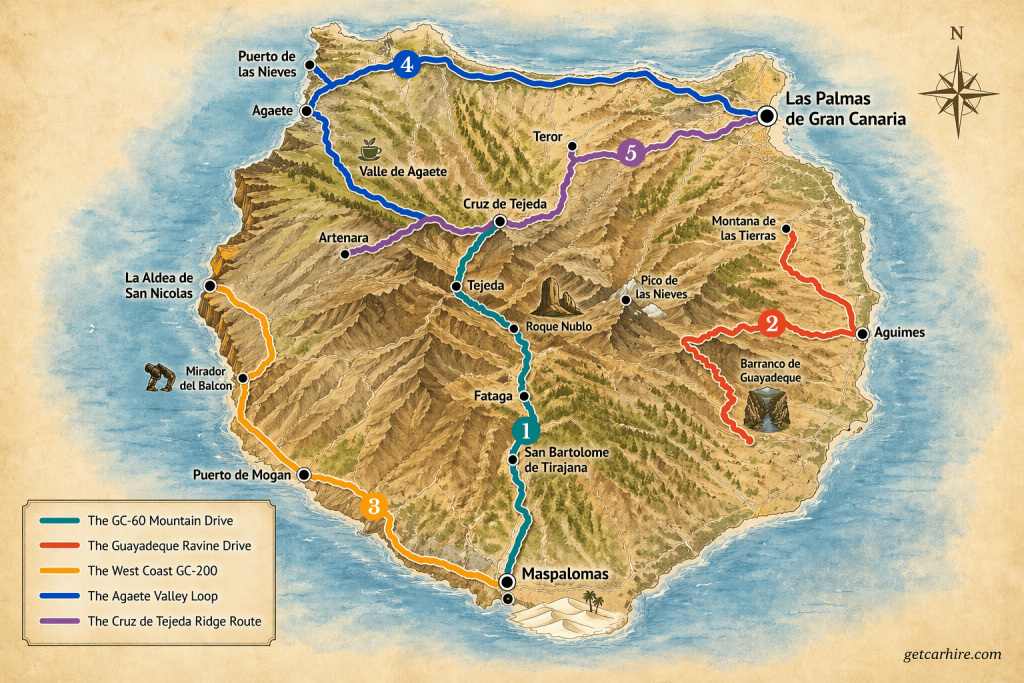
The road continues climbing into the pine forests. From here Roque Nublo (ROH-kay NOO-bloh), a 65-metre volcanic monolith at 1,813 metres above sea level, begins to appear on the horizon. Access is managed with designated parking areas and a short walk of approximately 1.5 kilometres to the base of the rock.
Book your access slot in advance during peak season. On a clear day the views extend to Tenerife and Mount Teide.
From Roque Nublo continue to Tejeda (teh-HEH-dah), a beautiful mountain village overlooking a volcanic caldera and one of Spain’s most beautiful villages. In February the surrounding hillsides fill with almond blossom during the island’s most celebrated seasonal festival.
Insider Tip: Parking directly at Roque Nublo is prohibited. The island uses designated parking areas at Tejeda and Cruz de los Llanos with an access booking system. Book your slot before arriving, especially in July and August. The walk from the car park to the base of the rock is approximately 1.5 kilometres and takes around 45 minutes return.
Food and Pit Stops: Drive 1
Restaurante Grill El Labrador, Fataga – traditional Canarian grill in the village of Fataga. The terrace overlooks the ravine. Try the cabrito (roasted kid goat) and mojo verde. Family run and unpretentious.
Parador Cruz de Tejeda – the national parador hotel at Cruz de Tejeda is the crossroads of the island’s mountain routes. The restaurant serves traditional Canarian cuisine with panoramic mountain views. Lunch on the terrace is a highlight of any Gran Canaria visit.
Tejeda village bakeries – before leaving Tejeda, try the traditional almond-based sweets at one of the village bakeries. Bienmesabe, an almond cream paste, and mazapan de almendra are the local specialities and make excellent food souvenirs.
Total distance: approximately 65 kilometres from Maspalomas to Tejeda. Allow a full day with the Fataga stop, Roque Nublo walk and lunch in Tejeda or Cruz de Tejeda.
Drive 2: The Barranco de Guayadeque
Gran Canaria’s Ancient Cave Ravine | GC-103
| Start | Aguimes or Ingenio on the GC-1 motorway |
| End | Montana de las Tierras at the top of the ravine |
| Distance | Approx 9 km into the ravine from Aguimes |
| Driving time | 30 minutes each way plus stops |
| Road | GC-103 from Aguimes |
| Difficulty | Easy. Well-maintained road throughout |
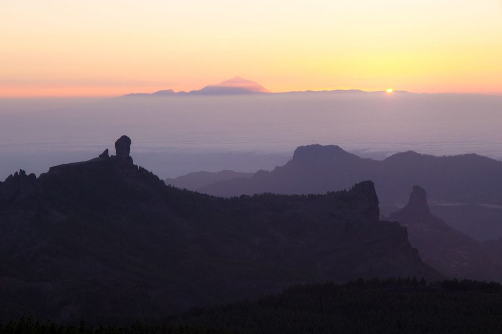
The Barranco de Guayadeque (bar-RAN-co day gwy-ah-DEH-gay) is one of the most distinctive drives on the island. This deep ravine in the southeast of Gran Canaria was one of the most densely populated areas of the island during pre-Hispanic times.
The cave dwellings that line its walls are still occupied today, many converted into restaurants, homes and a cave church.
The drive into the ravine from Aguimes is smooth and the scenery builds steadily. Towering volcanic cliffs rise on either side as the road winds deeper into the natural monument.
The vegetation becomes lusher as the ravine narrows, with almond and fig trees clinging to the cave-dotted walls. An interpretation centre near the entrance explains the geological history and the Guanche culture of the island’s aboriginal inhabitants.
The road ends at Montana de las Tierras at around 1,000 metres elevation, a small cluster of cave houses with long views back down to the eastern coast. There is no mobile coverage in the ravine, so download your route before entering. The return drive reveals an entirely different perspective as the morning light falls differently on the volcanic walls.
Food and Pit Stops: Drive 2
Restaurante Vega, Barranco de Guayadeque – carved directly into the ravine wall, this cave restaurant has been a family institution since 1981. Current owner Airam Vega serves Gran Canaria specialities including the signature cochino a la sal (suckling pig in salt) and conejo frito (fried rabbit). Book ahead for weekends.
La Era Restaurant, Barranco de Guayadeque – further up the ravine and also set in a cave. Good for local cheese, Guayadeque honey and the abocado wine, a Gran Canaria blend of sweet and red wine found almost nowhere else.
Canarian Cave House craft shop – a cave house near the Vega restaurant selling Guayadeque honey and local crafts. The pure honey from the ravine is among the best on the island and travels well as a food souvenir.
Total distance: approximately 9 kilometres into the ravine from Aguimes and back. Allow half a day with the interpretation centre and a proper lunch at one of the cave restaurants.
Drive 3: The West Coast GC-200
Mogan to La Aldea de San Nicolas via Mirador del Balcon | GC-200
| Start | Puerto de Mogan |
| End | La Aldea de San Nicolas |
| Distance | Approx 50 km |
| Driving time | 2 hours without stops |
| Road | GC-200 north from Mogan through Tamadaba Natural Park |
| Difficulty | Challenging. The GC-200 has 365 curves with sheer drops and narrow passing points. Not recommended for nervous drivers or in wet conditions |
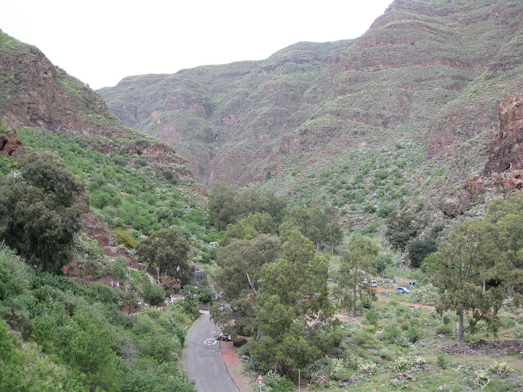
The GC-200 along Gran Canaria’s rugged west coast is the island’s most dramatic road. The route north from Puerto de Mogan hugs the cliff edge for much of its 50 kilometres, passing through the protected Tamadaba Natural Park and delivering views of the Atlantic that on clear days extend to La Palma and Tenerife.
The Mirador del Balcon (mee-rah-DOR del bal-CON) is the undisputed highlight of this drive. A viewing platform suspended above the cliff edge, it offers what many regard as the finest coastal panorama in the Canary Islands.
The west coast cliffs drop hundreds of metres to the sea below and the Tamadaba pine forest frames the view to the north. Arrive early to have the platform to yourself.
The road continues past Tamadaba to La Aldea de San Nicolas, a quiet agricultural town in a fertile valley almost entirely unknown to tourists. The tomatoes grown here supply much of mainland Spain. The contrast between the dramatic cliff road and the peaceful valley below is part of what makes this drive memorable.
Insider Tip: The GC-200 is a serious road. Sheer drops with limited barriers, narrow passing points and significant wind exposure on the cliff sections require full attention. Fill the tank in Puerto de Mogan before departing as there are no fuel stations between Mogan and La Aldea de San Nicolas. Allow considerably more time than the distance suggests.
Food and Pit Stops: Drive 3
Puerto de Mogan waterfront – start the drive with breakfast at one of the harbour cafes in Puerto de Mogan, often called Little Venice for its canal and flower-covered bridges. The fish restaurants here are among the best on the south coast.
Mirador del Balcon cafe – a small bar at the viewpoint serves coffee and light snacks. Basic but the view makes it unmissable. Arrive early for the quietest experience.
Restaurante El Palmeral, La Aldea de San Nicolas – local restaurant in the town square serving Canarian staples. The tomato salad uses produce grown in the valley outside the window.
Total distance: approximately 50 kilometres from Puerto de Mogan to La Aldea de San Nicolas. Allow a full day with the Mirador del Balcon stop and lunch at La Aldea.
Drive 4: The Agaete Valley and North Coast Loop
Las Palmas to Puerto de las Nieves and the Valle de Agaete | GC-2 / GC-291
| Start | Las Palmas de Gran Canaria |
| End | Puerto de las Nieves |
| Distance | Approx 70 km from Las Palmas via the GC-2 and GC-291 |
| Driving time | 1.5 hours without stops. Allow a full day |
| Road | GC-2 motorway north from Las Palmas, then GC-291 into Agaete and the valley |
| Difficulty | Easy to moderate. Good roads throughout |
The northwest of Gran Canaria is the greenest and least visited part of the island. The Valle de Agaete (VAH-yeh deh ah-GAH-teh) is a lush volcanic valley producing coffee, oranges and wine at elevations where the Canary Island humidity and altitude combine to create a microclimate found nowhere else in Europe. Gran Canaria produces the only commercially grown coffee in the European Union, and the Agaete valley is where it comes from.
The Finca La Laja coffee and wine estate at the heart of the valley has been producing Arabica beans for over 200 years and offers guided tours. The cafe at the adjacent Casa Romantica serves the coffee with views of surrounding mountains and dragon trees.
From the valley continue to Puerto de las Nieves, the small fishing port of Agaete. Natural rock pools sheltered from the Atlantic, a promenade of whitewashed buildings and several excellent seafood restaurants make this the most rewarding coastal stop in the north. The afternoon ferry to Tenerife departs from here if you want to extend the trip.
The return to Las Palmas can be varied by heading up into the Tamadaba pine forest from Agaete for views of the island’s northwest coastline. The Llanos de la Mimbre viewpoint inside the park offers, on a clear day, a view of Mount Teide on Tenerife 120 kilometres away.
Food and Pit Stops: Drive 4
Casa Romantica, Valle de Agaete – Michelin Guide listed farm-to-table restaurant at Finca La Laja. Tasting menus built entirely on estate produce including La Laja coffee, local wines and seasonal vegetables. Book ahead.
Ragu, Puerto de las Nieves – Canary-Italian fusion seafood restaurant in the harbour. Generous portions, outstanding presentation and a wine list featuring Canarian whites. The best evening meal stop on this drive.
Agaete natural pools (Las Salinas) – natural volcanic rock pools beside Puerto de las Nieves, free and well maintained. A swim here after the valley drive is the ideal way to end the afternoon.
Insider Tip: The Valle de Agaete is the only place in Europe where you can drink coffee grown on the same soil where you are sitting. The Finca La Laja guided tour takes 90 minutes and includes a tasting of La Laja Arabica alongside local wines from rare Canarian grape varieties. Book in advance as groups are small. The cafe at Casa Romantica serves the coffee without the tour if time is short.
Total distance: approximately 70 kilometres from Las Palmas to Puerto de las Nieves and back via Agaete. Allow a full day with the valley tour, lunch at Casa Romantica and a swim at the natural pools
Drive 5: The Cruz de Tejeda Ridge Route
Pico de las Nieves to Teror via Cruz de Tejeda and Artenara | GC-130 / GC-150 / GC-210 / GC-21
| Start | Pico de las Nieves summit viewpoint |
| End | Teror |
| Distance | Approx 45 km via Cruz de Tejeda, Artenara and Teror |
| Driving time | 2 hours without stops |
| Road | GC-130 to Pico de las Nieves, GC-150 to Cruz de Tejeda, GC-210 to Artenara, GC-21 to Teror |
| Difficulty | Moderate. Mountain roads with good surfaces. Some narrow sections near Artenara |
The ridge that runs across the centre of Gran Canaria from Pico de las Nieves (PEE-coh deh las NYEH-ves) in the east to Artenara (ar-teh-NAR-ah) in the west is the geographical spine of the island. This drive follows it from the highest point on Gran Canaria down through ancient pilgrimage routes to the most beautiful town on the island.
Begin at Pico de las Nieves, the island’s highest point at 1,949 metres. A road goes all the way to the summit and on a clear day the views extend to Tenerife, La Gomera, El Hierro and Fuerteventura simultaneously. From Pico de las Nieves the GC-150 runs west along the ridge to Cruz de Tejeda (krooss deh teh-HEH-dah), the ancient crossroads where all the island’s mountain paths converge. A stone cross here has stood at this meeting point since the 17th century.
Continue west on the GC-210 to Artenara, the highest village on Gran Canaria at 1,270 metres. Artenara is a cave village, its homes cut directly into the volcanic rock face, with a cave church accessible through a tunnel in the hillside. The views of Roque Nublo from the Mirador del Amagro viewpoint here are among the finest on the island.
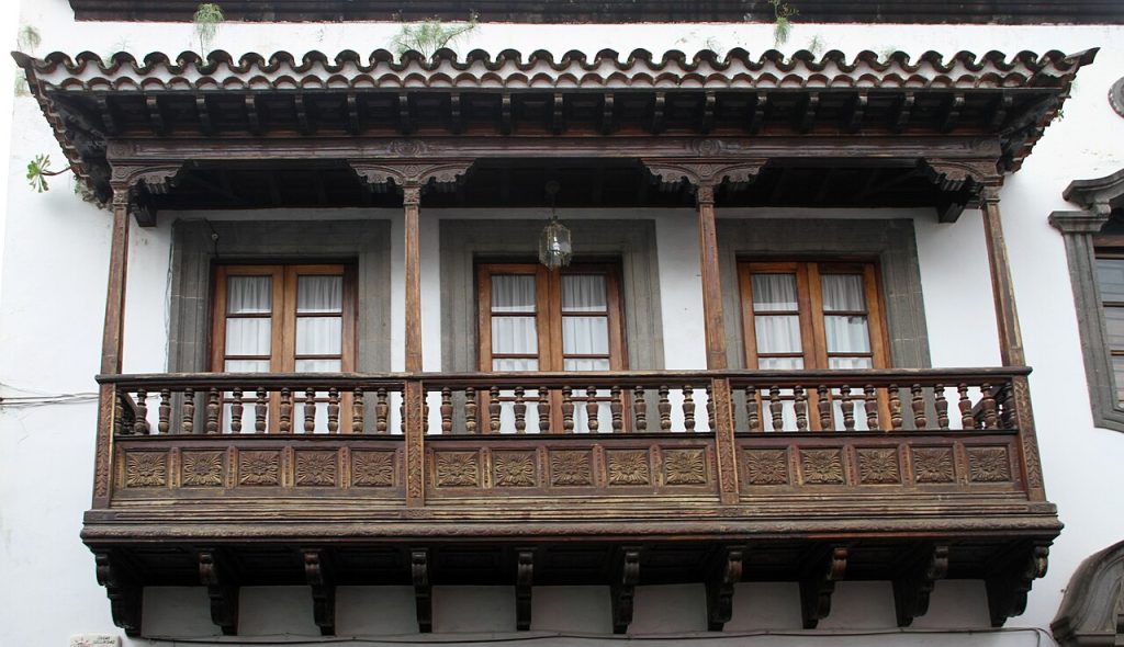
Descend from Artenara on the GC-21 through Valleseco to Teror (teh-ROR), widely regarded as the most beautiful town in the Canary Islands. Teror’s historic centre is lined with traditional Canarian houses with carved wooden balconies. The Sunday market fills the main square with local produce and the Basilica de Nuestra Senora del Pino is the most important pilgrimage site in Gran Canaria.
Insider Tip: The drive back from Teror to Las Palmas or the southern resorts along the GC-21 at dusk, with the sun dropping behind you and the eastern sky turning amber over the plain, is one of the finest ends to a day on the island. Time your departure from Teror about an hour before sunset. The light on the limestone walls of the interior villages at that hour makes the slower pace entirely worthwhile.
Food and Pit Stops: Drive 5
Parador Cruz de Tejeda restaurant – the parador at the mountain crossroads serves traditional Canarian cuisine. The lunch menu includes rabbit in salmorejo sauce, fresh cheese with palm honey and bienmesabe almond cream dessert. The terrace view of both the Tejeda caldera and the north coast is exceptional.
Cueva Bar, Artenara – a bar set in a cave in the village with views of Roque Nublo. Simple food and good local wine. The cave setting with mountain panoramas at 1,270 metres is unlike anything else on the island.
Teror Sunday market – if driving this route on a Sunday, the market in Teror’s main square sells the best local cheese, honey and bienmesabe on the island. The chorizo de Teror sausage, soft and spreadable, is a local speciality sold nowhere else.
Total distance: approximately 45 kilometres from Pico de las Nieves to Teror. Allow a full day with stops at Cruz de Tejeda, Artenara and Teror.
Gran Canaria UNESCO Biosphere Reserve
Much of Gran Canaria’s interior is protected as part of the Gran Canaria UNESCO Biosphere Reserve, designated in recognition of the island’s volcanic landscape and high concentration of endemic species. All five drives in this guide pass through or border the protected zone.
Driving within the Biosphere Reserve requires staying on marked roads. Off-road driving is prohibited and fines are substantial. The roads described in this guide are all sealed or graded public roads. The GC-606 and some smaller interior tracks are extremely narrow and not recommended without local knowledge.
Frequently Asked Questions
How long does it take to drive around Gran Canaria?
The island is approximately 60 kilometres from north to south and 50 kilometres east to west. The GC-1 motorway from Las Palmas to Maspalomas takes under an hour. A proper circuit of the island including the mountain interior and both coasts takes at least two full days driven at a relaxed pace.
What is the best food to try in Gran Canaria?
Papas arrugadas with mojo sauce (wrinkled potatoes with green or red mojo dip) is the essential starting point and available everywhere. Cabrito (roasted kid goat) and conejo frito (fried rabbit) are the traditional mountain dishes. Bienmesabe, an almond cream paste, is the island’s signature sweet. Chorizo de Teror, a spreadable paprika-seasoned sausage, is the best food souvenir and available at Teror market and roadside farm shops.
Are the roads in Gran Canaria suitable for all hire cars?
The GC-1 motorway and main secondary roads are in excellent condition. The GC-200 west coast road and several mountain interior routes are more demanding with narrow sections, hairpin bends and sheer drops. A standard compact hire car handles all five drives in dry conditions. A small SUV adds comfort on the access tracks to some remote viewpoints.
Do you need a hire car to explore Gran Canaria properly?
For the resorts and Las Palmas the bus network is adequate. For the mountain interior, the Barranco de Guayadeque, the west coast GC-200 and the Cruz de Tejeda ridge route, a hire car is the only practical means of getting there on your own schedule. The five drives above give a clear picture of what the island offers with your own wheels.
When is the best time to hire a car in Gran Canaria?
Gran Canaria is a year-round destination with mild temperatures throughout. May, June and September offer the best combination of good weather, manageable traffic on the mountain roads and competitive hire car pricing. July and August are the busiest and most expensive months. Winter driving in the central mountains can bring low cloud to the higher routes but the roads themselves remain open year round.
Plan Your Gran Canaria Road Trip
Each of the five drives above can be completed as a standalone day out from any resort on the island. Together they cover Gran Canaria in full: both coastlines, the volcanic mountain interior, prehistoric sites, two cities and some of the finest food in the Canary Islands along the way. The island rewards unhurried driving more than almost anywhere else in southern Europe.
Compare hire car deals across all Gran Canaria pickup locations alongside the rest of Spain’s islands on our car hire in Spain page. Transparent pricing, no hidden fees and five drives genuinely worth making.
About the Author
Darryl Antonio is CEO of Digitalhound, a London-based digital marketing agency with over two decades of experience in SEO and content strategy. Darryl oversees digital strategy across all sectors the agency represents and manages content production and digital strategy for Getcarhire.com.