Lanzarote is unlike any other island in Europe. Formed by volcanic eruptions that devastated the landscape between 1730 and 1736, it has been shaped by fire in a way that no Mediterranean destination can match: black lava fields, volcanic craters, wine grown in pits scooped from ash, and a coastal palette of rust-red, black and vivid turquoise that shifts with the light.
The 5 best scenic drives in Lanzarote take you through all of this, and through the extraordinary architectural legacy of César Manrique, the local artist who spent his career ensuring that the island’s development never overshadowed its landscape. Each drive in this guide includes route detail, driving times, food stops and what to order when you get there.
Table of Contents
The 5 Best Scenic Drives in Lanzarote at a Glance
Drive 1: The Volcanic South. Arrecife to Timanfaya National Park via La Geria wine region. Approximately 60 kilometres. Full day. Stop at Bodega La Geria or Restaurante Bodegas Rubicon for lunch in the vineyards.
Drive 2: The Northern Loop. Arrecife to Mirador del Rio via Jameos del Agua and Cueva de los Verdes. Approximately 65 kilometres. Full day. Lunch at the restaurant inside Jameos del Agua, where the seafood is served beside a volcanic cave and underground lake.
Drive 3: The West Coast Road. Timanfaya edge to El Golfo green lagoon and Janubio salt flats. Approximately 35 kilometres. Half day. Lunch at one of the seafood restaurants in El Golfo village overlooking the Charco de los Clicos.
Drive 4: The César Manrique Trail. San Bartolomé to Mirador de Haría via the César Manrique Foundation and Teguise. Approximately 50 kilometres. Full day. Stop at the cafe at the César Manrique Foundation and the Sunday market in Teguise if timing allows.
Drive 5: The Southern Beaches Drive. Arrecife to Papagayo coves via Puerto Calero marina and Playa Blanca. Approximately 55 kilometres. Half day to full day. Lunch at the marina in Puerto Calero or a beach bar at Papagayo.
5 Best Scenic Drives in Lanzarote: What to Know Before You Set Off
Lanzarote is one of the easiest islands in Europe to drive. The roads are in excellent condition, traffic outside Arrecife is minimal and the island is compact enough to cross from north to south in under an hour.
Spain drives on the right. Speed limits follow the standard framework set by the Direccion General de Trafico (pronounced dee-RECK-syon heh-neh-RAL deh TRAH-fee-ko), Spain’s national road traffic authority: 50 km/h in towns and villages, 90 km/h on open rural roads, 110 km/h on the main LZ-1 and LZ-2 arterial roads. The legal blood alcohol limit is 0.05 per cent, lower than in the UK. It is illegal to drive in flip-flops. Both are enforced.
The two main roads are the LZ-1, running north from Arrecife to Orzola, and the LZ-2, running south from Arrecife to Playa Blanca. All five scenic drives in this guide connect to one or both. Petrol stations are widely available throughout the island. Parking is free in most areas outside Arrecife and the main resort centres.
One practical note specific to Lanzarote: Timanfaya National Park does not allow private vehicles to drive through the volcanic interior. Entry to the park includes a compulsory guided coach tour along the Ruta de los Volcanes (pronounced ROO-ta deh loss vol-KAH-ness, meaning the route of the volcanoes), which lasts approximately 45 minutes.
You drive your hire car to the park entrance at Islote de Hilario (pronounced iss-LOW-teh deh ee-LAH-ree-o) and board a coach there. Queues in July and August can be significant: arriving before 9.30am or after 3pm avoids the worst waits.
Insider Tip: El Diablo restaurant at the Islote de Hilario entrance to Timanfaya National Park cooks food using natural volcanic heat from the earth below the grill. The restaurant was designed by César Manrique and the grill sits directly above a volcanic vent. It is one of the most extraordinary dining experiences in Europe and does not require park entry to visit. Book in advance for lunch as tables fill quickly throughout summer.
Drive 1: The Volcanic South
Arrecife to Timanfaya National Park via La Geria
Arrecife (pronounced a-reh-SEE-feh, meaning reef), the island’s capital, sits on the east coast. Leave heading south-west on the LZ-30 through the town of San Bartolomé (pronounced san bar-to-lo-MEH), which sits at the geographical heart of the island and houses the Monumento al Campesino (pronounced mo-noo-MEN-to al kam-peh-SEE-no, meaning the monument to the peasant farmer), a striking white sculpture by César Manrique celebrating the island’s farming heritage. The adjacent museum and restaurant uses local produce and is worth a brief stop.
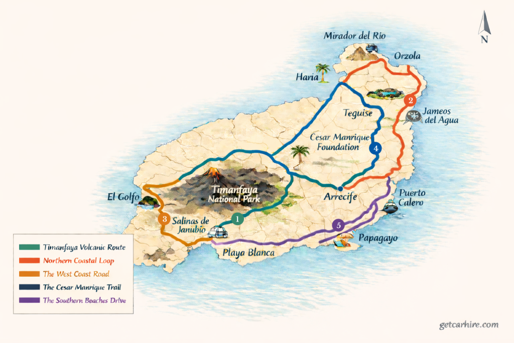
Continue south-west on the LZ-30 into La Geria (pronounced la HEH-ree-a), Lanzarote’s wine region. The landscape here is unlike anything else in Europe: the vines grow in individual pits scooped from black volcanic ash, each one protected from the wind by a low curved wall of lava stone called a zoco (pronounced SO-ko).
The malvasia volcánica (pronounced mal-va-SEE-a vol-KAH-nee-ka) grape grown here produces an aromatic white wine unique to the island. The oldest and most visited winery is Bodega La Geria (established late 19th century), which offers 45-minute guided tours and tastings by the glass. The adjacent cafe-bar serves tapas at around six to eight euros each.
For lunch with a view, Restaurante Bodegas Rubicon (pronounced bo-DEH-gas roo-bee-KON) on the main road through La Geria is consistently rated the best restaurant in the region: a terrace overlooking the vineyards with volcanic mountains behind, serving traditional Canarian dishes including grilled local goat’s cheese with mojo sauce (pronounced MO-ho, meaning a spiced vinaigrette condiment), fried rabbit and pork in red wine.
The restaurant remains open for dinner, one of the few in La Geria that does. The wines poured here are from the surrounding bodegas.
Continue west on the LZ-67 to the entrance of Timanfaya National Park (pronounced tee-man-FAH-ya), which the Parques Nacionales authority manages as one of Spain’s most protected natural areas. The park covers 51 square kilometres of volcanic terrain created by eruptions between 1730 and 1736 that lasted six years and buried dozens of villages under lava. The Ruta de los Volcanes coach tour through the volcanic interior is included in the entry fee.
Total distance: approximately 60 kilometres from Arrecife to Timanfaya and back. Allow a full day with a winery visit in La Geria and the Timanfaya coach tour.
Drive 2: The Northern Loop
Arrecife to Mirador del Rio via Jameos del Agua and Cueva de los Verdes
Head north from Arrecife on the LZ-1, the island’s main northern artery. The first significant stop is Jameos del Agua (pronounced ha-MEH-os del AH-gwa, meaning the opening of the water), a volcanic cave and lagoon complex created by César Manrique and opened in 1966.
The site contains an underground saltwater lagoon that connects to the sea through a submerged lava tube, and is home to a species of blind albino crab found nowhere else on earth: the Munidopsis polymorpha.
The restaurant inside the cave complex serves seafood at tables overlooking the lagoon, with pumpkin soup consistently cited as the outstanding starter. The setting is one of the most extraordinary in the Canary Islands.
Continue north on the LZ-1 to Cueva de los Verdes (pronounced KWEH-va deh loss VEH-rdes, meaning the cave of the greens), a 3,000-year-old lava tube that extends for six kilometres above sea level and a further 1.5 kilometres beneath the sea, making it the world’s longest known submarine lava tube.
Guided tours take approximately 45 minutes and include an art installation at the deepest point that has surprised visitors consistently since the cave opened. Book tickets in advance in summer.
Continue north to Orzola (pronounced or-SOH-la), the northernmost town on the island, where the ferry to the car-free island of La Graciosa (pronounced la gra-SYOH-sa) departs.
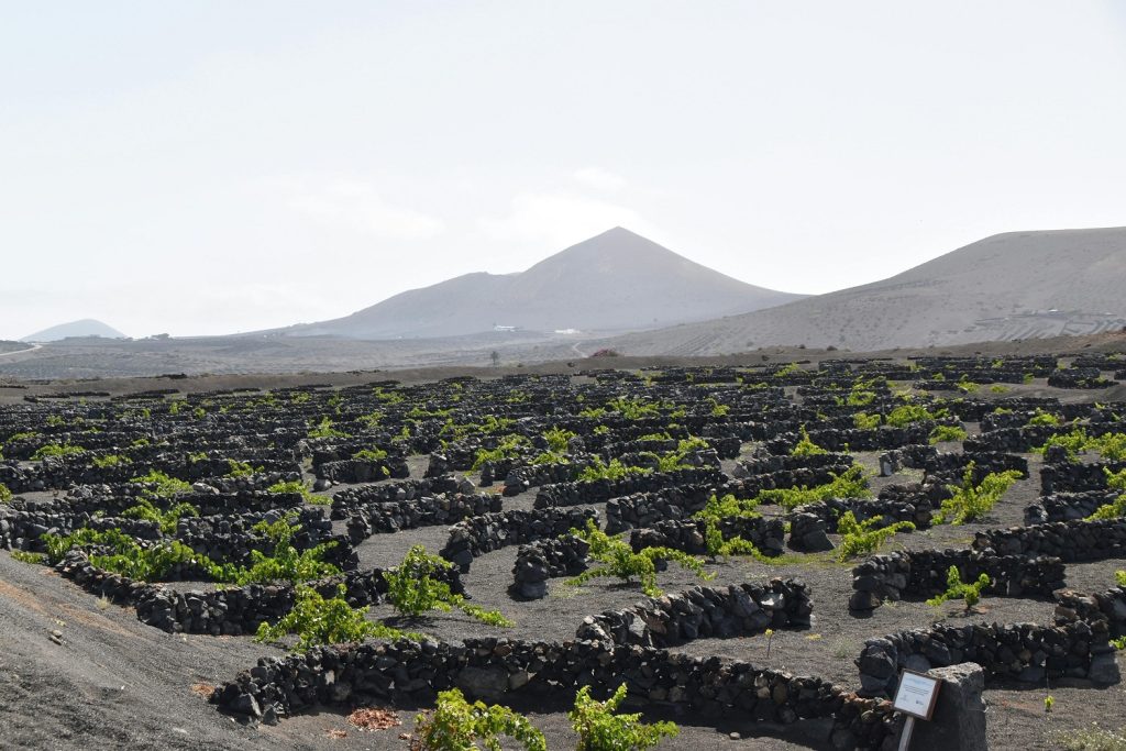
From Orzola head south-west on the LZ-201 to the Mirador del Rio (pronounced mee-ra-DOR del REE-o, meaning the viewpoint of the river), another César Manrique creation built into the clifftop with views across the strait to La Graciosa and the Atlantic beyond. Entry costs approximately five euros. Arrive before midday for the best light.
Insider Tip: The LZ-202 road running along the clifftops south of Mirador del Rio towards Ye is one of the most dramatic stretches of road on the island, barely wide enough for two cars and with sheer drops to the sea on the western side. It is worth driving in a small car specifically for this section. Overconfident drivers in larger vehicles have found it uncomfortable. The views are exceptional, but pull over only where the road widens.
Total distance: approximately 65 kilometres from Arrecife to Mirador del Rio and back. Allow a full day with stops at Jameos del Agua, Cueva de los Verdes and the mirador.
Drive 3: The West Coast Road
Timanfaya Edge to El Golfo and Janubio Salt Flats
This is the shortest and most visually concentrated drive on the island, covering the west coast from the edge of Timanfaya south to the Janubio salt flats. It works either as a standalone half-day drive from any resort or as an extension of Drive 1 on the same day.
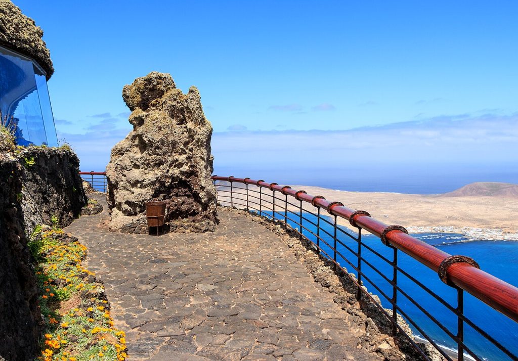
Leave Timanfaya heading north-west on the LZ-602 to El Golfo (pronounced el GOL-fo, meaning the gulf), a small fishing village on the west coast famous for the Charco de los Clicos (pronounced CHAR-ko deh loss KLEE-kos, meaning the pool of the clicos), an emerald-green lagoon sitting inside a half-collapsed volcanic crater alongside black sand and rust-red cliffs.
The contrast of colours, green lagoon, black sand, red rock and blue Atlantic, makes this one of the most photographed spots in the Canary Islands. The viewpoint above is free and the walk down to the beach takes five minutes.
The village of El Golfo itself has a row of seafood restaurants along the seafront, all of them straightforward and all serving fresh fish.
The speciality is vieja (pronounced VEE-eh-ha, meaning parrotfish), a locally caught fish grilled and served with papas arrugadas (pronounced PA-pass a-roo-GAH-das, meaning wrinkled potatoes), the traditional Canarian small potatoes boiled in heavily salted water and served with mojo sauce. The combination is the essential Lanzarote meal.
Continue south on the LZ-703 to Los Hervideros (pronounced loss er-vee-DEH-ross, meaning the boiling places), where the sea forces through volcanic rock formations creating natural blowholes and surge channels. Park on the roadside and walk the short path along the cliff edge.
Five minutes south brings you to the Salinas de Janubio (pronounced sa-LEE-nass deh ha-NOO-bee-o), the largest salt flats in the Canary Islands, still producing artisanal sea salt using traditional methods.
The Mirador de las Salinas viewpoint above the salt pans has a restaurant with a terrace overlooking the glistening white and pink expanse of the flats.
Total distance: approximately 35 kilometres. Allow half a day with stops at El Golfo, Los Hervideros and Janubio. Combine with Drive 1 for a full day from Arrecife.
Drive 4: The César Manrique Trail
San Bartolomé to Mirador de Haría via the César Manrique Foundation and Teguise
César Manrique (pronounced SEH-sar man-REE-keh, 1919 to 1992) was a Lanzarote-born artist and architect who spent his career shaping the island’s relationship with its own landscape.
He designed Jameos del Agua, Mirador del Rio, the Timanfaya restaurant and the Cactus Garden among other works, and campaigned successfully against the high-rise development that has dominated other Canary Islands. His influence is visible on every drive, but this route connects his major works and legacy sites directly.
Begin at the César Manrique Foundation (Fundación César Manrique, pronounced foon-da-SYON SEH-sar man-REE-keh) at Taro de Tahiche (pronounced TA-ro deh ta-EE-cheh), a few kilometres north of Arrecife on the LZ-1.
Manrique built his home inside a series of natural volcanic bubbles left by the 1730 eruptions, connecting five of them into a house that disappears entirely into the landscape from outside. The foundation, managed by the Fundacion Cesar Manrique, opens daily and includes the house, sculpture garden, gallery and cafe. Allow at least two hours.
Continue north-west to Teguise (pronounced teh-GEE-seh), the former capital of Lanzarote and one of the best-preserved historic towns in the Canary Islands. Its castle, Castillo de Santa Barbara, sits above the town on a volcanic cone and was used historically as a lookout against pirate raids.
On Sunday mornings between 9am and 2pm Teguise hosts the largest market on the island, with local produce, wines, arts and crafts spread across the main square and surrounding streets. The town is quieter on other days and easier to explore on foot at a relaxed pace.
Drive north on the LZ-10 to the Mirador de Haría (pronounced mee-ra-DOR deh a-REE-a), a viewpoint above the Valley of a Thousand Palm Trees, where a wide basin of Phoenix canariensis palms fills a volcanic depression between the hills.
The light in the valley in the late afternoon is exceptional. The town of Haría (pronounced a-REE-a) itself below the viewpoint is the most characterful village on the island: white walls, shaded squares and a distinct unhurried quality.
Insider Tip: The weekly Sunday market in Teguise is at its best between 9am and 11am before the tour coaches arrive from the southern resorts. Park on the approach roads rather than in the town itself, where streets are narrow and space fills quickly. The local cheese, queso de cabra de Lanzarote (pronounced KEH-so deh KA-bra, meaning Lanzarote goat’s cheese), is excellent and available at the farm produce stalls at the market’s northern end.

Total distance: approximately 50 kilometres from Arrecife to Haría and back. Allow a full day with two hours at the Foundation, time in Teguise and the drive to the Mirador de Haría.
Drive 5: The Southern Beaches Drive
Arrecife to Papagayo Coves via Puerto Calero and Playa Blanca
The south of Lanzarote holds the island’s finest beaches and its most relaxed driving. The LZ-2 runs from Arrecife south to Playa Blanca along the eastern coast and is the smoothest road on the island. This drive follows it south with detours to the marina at Puerto Calero and the Papagayo coves at the island’s southern tip.
Leave Arrecife south on the LZ-2. After approximately 12 kilometres turn west to Puerto Calero (pronounced PWER-to ka-LEH-ro), a purpose-built marina that is one of the most attractive on the island, lined with restaurants and occupied by sailing yachts and motor cruisers.
The marina hosts a market on Tuesdays and Fridays. For breakfast or a morning coffee, the waterfront cafes here are considerably calmer than anything in the main resort areas. Puerto del Carmen, the main resort on the south-east coast, lies just to the north and has a long promenade of beach bars and restaurants including La Casa Roja, widely regarded as among the best seafood restaurants in the south.
Continue south on the LZ-2 to Playa Blanca (pronounced PLA-ya BLAN-ka, meaning white beach), the resort at the island’s southern tip. From Playa Blanca, follow the signs east for Los Ajaches (pronounced loss a-HA-chess) Natural Monument and the Papagayo (pronounced pa-pa-GA-yo) beach access road.
Entry to the natural monument area costs three euros. The access track to the beaches is unpaved but manageable in a standard hire car in dry conditions. Papagayo is a series of golden sand coves set below low cliffs, generally acknowledged as the finest beach complex on the island.
For lunch, the beach bar at Playa Papagayo operates throughout the summer season serving simple grilled fish and cold drinks at tables on the sand. For a more substantial meal, the restaurant at El Chiringuito in Playa Blanca is directly on the beach and consistently rated for grilled calamari and fresh fish.
Insider Tip: The Papagayo access track gets very busy after 10am in July and August. Arriving before 9am means a short queue at the entry barrier, easy parking close to the best coves and the beaches to yourself for the first hour. The water here is sheltered and exceptionally clear. Cala Blanca and Playa del Pozo, the two smaller coves to the east of the main Papagayo beach, are less visited and worth the extra five minutes of walking.
Total distance: approximately 55 kilometres from Arrecife to Papagayo and back. Allow a half day to full day depending on beach time at Papagayo.
Practical Notes for All Five Drives
Lanzarote Airport (IATA code: ACE) sits approximately five kilometres south-west of Arrecife and is the arrival point for all major hire car suppliers. Book three to four months in advance for July and August travel. The island is compact enough that all five drives are within easy reach of any resort.
There are no toll roads on Lanzarote. Fuel prices are slightly lower than mainland Spain due to the island’s tax status as a Canary Island free trade zone. Arrecife’s one-way system and limited parking make it worth parking on the outskirts and walking in, particularly around the Charco de San Gines harbour area.
For a full comparison of deals across all Lanzarote pickup locations and the rest of the Canary Islands, visit Getcarhire.com/spain.
Frequently Asked Questions
How long does it take to drive around Lanzarote?
The island is approximately 60 kilometres from north to south along the LZ-1 and LZ-2. A non-stop circuit of the perimeter takes around two hours. Driven properly with stops at the main sights, the five drives described above cover the whole island across three to four days.
What is the best food to try in Lanzarote?
Papas arrugadas with mojo sauce is the essential Canarian dish, served everywhere on the island. Vieja (parrotfish) grilled and served with the same accompaniment is the local seafood speciality, best eaten in El Golfo. Malvasia volcánica, the white wine grown in the La Geria lava fields, is the drink to order alongside any meal on the island.
Can you drive through Timanfaya National Park in your hire car?
Not through the volcanic interior. Private vehicles drive to the park entrance at Islote de Hilario, where entry includes a compulsory 45-minute guided coach tour along the Ruta de los Volcanes. The surrounding park roads are open to hire cars and the perimeter drive along the LZ-67 is rewarding in itself.
Are there toll roads in Lanzarote?
No. There are no toll roads on Lanzarote or anywhere in the Canary Islands. Fuel prices are slightly lower than mainland Spain. The only driving cost beyond fuel is the three-euro access fee for the Los Ajaches Natural Monument on Drive 5.
When is the best time to hire a car in Lanzarote?
Lanzarote has a year-round mild climate and is drivable in every month. For the busiest sights – Timanfaya, Jameos del Agua and Papagayo – May, October and November offer good weather, smaller crowds and more competitive hire car prices. July and August are the most expensive months with the longest queues at the major attractions.
Plan Your Lanzarote Road Trip
No other island in Europe offers driving like Lanzarote. The volcanic landscape, the César Manrique legacy, the wine region and the south coast beaches each reward a full day on the road, and none of the five drives above overlaps with another.
The island is compact, the roads are excellent and the only thing that slows you down is stopping to look at things worth stopping for. Ready to book? Compare deals across Lanzarote and the Canary Islands on our car hire in Spain. Transparent pricing, no hidden fees and five drives that are unlike anything else in Spain.