Most visitors to Tenerife spend their holiday between the southern resorts and a day trip to Mount Teide. Both are worthwhile.
But the island has a driving network that reveals extraordinary landscapes within an hour of any resort: ancient laurel forests older than the ice age, a mountain village perched on a knife-edge ridge above a gorge, 600-metre volcanic cliffs that the Guanche people called the Wall of Hell and a volcanic national park that covers a third of the island.
This guide covers the 5 best scenic drives in Tenerife, each one taking you through a different face of the island, with food stops, practical driving notes and road numbers throughout.
Table of Contents
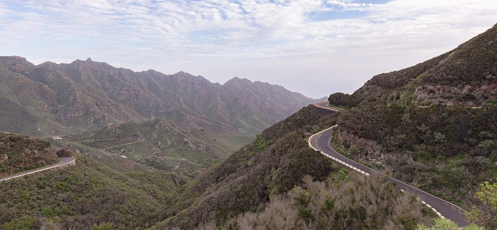
The 5 Best Scenic Drives in Tenerife at a Glance
Drive 1: The TF-21 Through Teide National Park. Vilaflor to El Portillo via the volcanic heart of the island. Approximately 45 kilometres. Full day. Lunch at the Parador de Las Canadas del Teide at the foot of Mount Teide.
Drive 2: The Masca Valley Road. Santiago del Teide to Masca via the TF-436. Approximately 37 kilometres return. Half day. Arrive before 9am to beat the crowds. Breakfast in Santiago del Teide before departing.
Drive 3: The Anaga Rural Park Loop. La Laguna to Taganana and Playa de Benijo via the TF-12. Approximately 50 kilometres. Full day. Lunch at a seafood restaurant in San Andres or Taganana.
Drive 4: The North Coast Loop. Puerto de la Cruz to Garachico and Buenavista del Norte via the TF-5 and TF-82. Approximately 60 kilometres. Full day. Lunch in Garachico, one of the best-preserved colonial towns in the Canary Islands.
Drive 5: The Los Gigantes Cliff Drive. Santiago del Teide to Los Gigantes via the TF-82 and TF-454. Approximately 30 kilometres. Half day. Sundowner at the Mirador Archipenque viewpoint above the cliffs.
What You Need to Know Before Driving in Tenerife
Spain drives on the right. Tenerife has an extensive road network connecting the southern resorts, the capital Santa Cruz and the mountain interior. The TF-1 motorway runs along the south coast and the TF-5 along the north, meeting at Santa Cruz. All five drives in this guide branch from these main arteries into the dramatic interior and coastal highlands.
Speed limits follow the standard Spanish framework: 50 km/h in towns, 90 km/h on rural roads and 120 km/h on motorways. Inside Teide National Park the limit is 70 km/h throughout. For full documentation requirements and driving regulations refer to the official DGT guidance for drivers in Spain.
Mountain road caution: The TF-436 Masca road and parts of the Anaga TF-12 are narrow with hairpin bends and significant drop-offs. A standard compact hire car handles all five drives but choose a smaller model for the narrowest sections.
Parking: Masca village has very limited parking and fills early. Teide National Park access points fill by mid-morning in peak season. For both, arrive before 9am.
Drive 1: The TF-21 Through Teide National Park
Vilaflor to El Portillo via the Volcanic Heart of Tenerife | TF-21
| Start | Vilaflor, the highest village in Spain at 1,450 metres |
| End | El Portillo visitor centre on the north side of Teide National Park |
| Distance | Approx 45 km |
| Driving time | 1.5 hours without stops. Allow a full day |
| Road | TF-21 north through Teide National Park |
| Difficulty | Easy to moderate. Road is wide and well-maintained with ample viewpoint parking throughout |
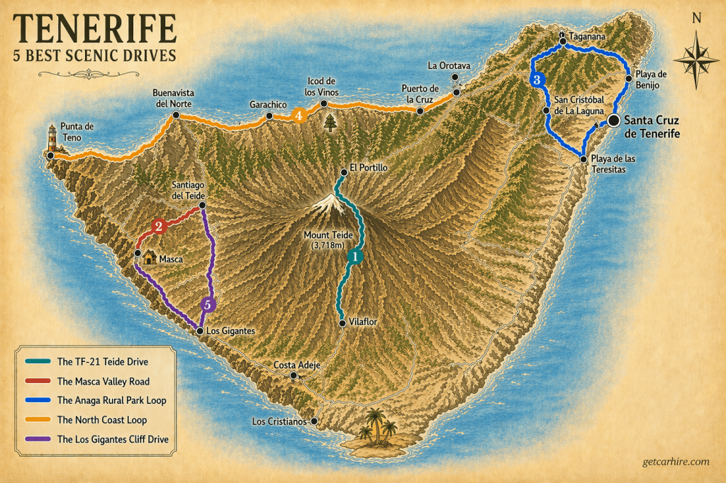
The TF-21 is the most accessible and most rewarding scenic drive on the island. From Vilaflor (vee-la-FLOR), the road climbs through pine forests before the vegetation falls away entirely and the landscape becomes something else: vast fields of solidified lava in rust-red and black, the volcanic cones of Las Canadas del Teide stretching to the horizon and the summit of Mount Teide rising 3,715 metres above sea level ahead.
Teide is the highest peak in Spain and the third largest volcano in the world measured from its oceanic base. The national park it anchors is a UNESCO World Heritage Site and one of the most visited natural attractions in Europe.
The TF-21 crosses this landscape from south to north with a series of viewpoints that reward stopping at every one of them. The Roques de Garcia rock formations about halfway through the park are the most photographed spot on the island.
The road continues north through the Las Canadas caldera before descending through pine forest to the El Portillo visitor centre. From here the TF-24 descends back to La Laguna or the TF-21 continues north to La Orotava and Puerto de la Cruz.
Insider Tip: The TF-21 becomes very busy from mid-morning. Driving it at dawn or in the late afternoon gives a completely different experience: the light on the lava fields at sunrise and sunset is extraordinary and the road is almost empty. If you plan to take the cable car to the summit, book the ticket online well in advance as it sells out weeks ahead in peak season.
Food and Pit Stops: Drive 1
Parador de Las Canadas del Teide – the national parador hotel sits at 2,150 metres in the heart of the park at the foot of Teide. The restaurant serves traditional Canarian cuisine including papas arrugadas with mojo sauce, rabbit stew and fresh fish. Lunch on the terrace with the volcano behind you is one of the great Tenerife experiences.
El Portillo visitor centre cafe – serves coffee and light snacks. Good stopping point before descending to the north coast.
La Orotava – descending from El Portillo brings you through La Orotava, a UNESCO-listed colonial town with some of the finest wooden balconied buildings in the Canary Islands. The main square has excellent traditional restaurants.
Total distance: approximately 45 kilometres from Vilaflor to El Portillo. Allow a full day with viewpoint stops, the Roques de Garcia walk and lunch at the Parador.
Drive 2: The Masca Valley Road
Santiago del Teide to Masca via the Teno Mountains | TF-436
| Start | Santiago del Teide |
| End | Masca village |
| Distance | Approx 37 km return |
| Driving time | 50 to 60 minutes each way. Allow a half day minimum |
| Road | TF-436 south-west from Santiago del Teide |
| Difficulty | Challenging. Extremely narrow with sharp hairpin bends and significant drops. Not recommended for nervous drivers. Arrive before 9am to avoid tour buses |
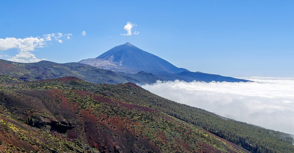
The TF-436 to Masca is the most famous road on the island and one of the most dramatic in Europe. It leaves Santiago del Teide heading south-west into the Teno Mountains, climbing to a ridge before dropping through a series of hairpin bends into a gorge so deep and vertical it barely sees sunlight. Give a gentle horn at blind corners as locals do.
The Mirador de Cherfe viewpoint about halfway down offers a wide panorama of the valley. Continue descending to Masca village (MASS-ka), a cluster of whitewashed and stone houses at 650 metres elevation, framed by towering cliffs and the distinctive Roque de Masca rock formation rising behind it.
The road does not continue beyond Masca in passable form. Return the same way.
Insider Tip: Parking in Masca fills completely by mid-morning in peak season. Arrive before 9am to guarantee a space. Leave nothing visible in the car as theft from hire cars is a known problem. Choose a smaller model if possible as the road is very narrow when meeting oncoming traffic.
Food and Pit Stops: Drive 2
Bar Restaurante El Patio, Santiago del Teide – start the drive with breakfast before descending. Traditional Canarian breakfast of tostada with local cheese and tomato.
Masca village cafes – several small cafes and restaurants serve simple Canarian food. Try the barraquito, the traditional Canarian layered coffee with condensed milk, liqueur and cinnamon.
Los Gigantes harbour restaurants – combining Drive 2 with a visit to Los Gigantes makes a natural full-day itinerary with excellent fresh seafood on the harbour.
Total distance: approximately 37 kilometres return. Allow a half day minimum, more if combining with Los Gigantes.
Drive 3: The Anaga Rural Park Loop
La Laguna to Taganana and Playa de Benijo via the Ancient Laurel Forest | TF-12 / TF-134
| Start | San Cristobal de La Laguna |
| End | Playa de Benijo or Playa de las Teresitas |
| Distance | Approx 50 km |
| Driving time | 2 hours without stops. Allow a full day |
| Road | TF-12 east from La Laguna through Anaga Rural Park, TF-134 to the coast |
| Difficulty | Moderate to challenging. Some sections narrow with mist common in the forest. Drive slowly and carefully |
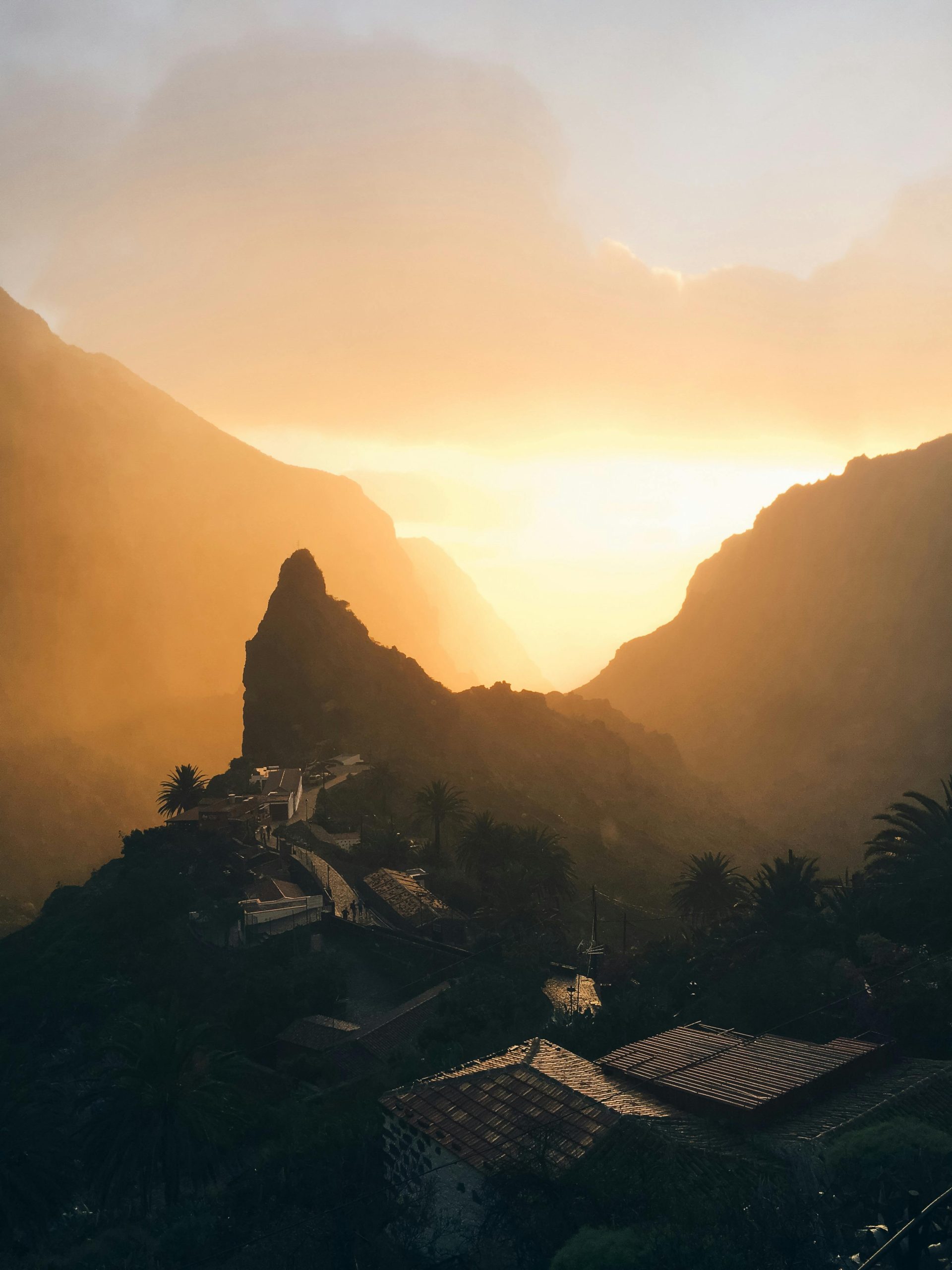
The Anaga Rural Park in the far north-east of Tenerife is the oldest part of the island geologically and one of the most remarkable landscapes in the Canary Islands. The TF-12 from La Laguna climbs into a dense laurel forest that predates the last ice age, one of the last remaining examples of the subtropical forest that once covered much of southern Europe and North Africa.
The viewpoints at Pico del Ingles and Cruz del Carmen offer long views across the ravines and north coast. The road continues east through the forest to Taganana (ta-ga-NA-na), a remote coastal village surrounded by towering cliffs. The black-sand beach at Playa de Benijo (PLAY-a de beh-NEE-ho) at the end of this road is wild and unspoiled with waves from the open Atlantic and no facilities of any kind.
Return via Playa de las Teresitas, the long golden-sand beach near Santa Cruz, for a complete contrast before heading back to the motorway.
Insider Tip: The Anaga forest is frequently in low cloud or mist, particularly in the morning. This is normal and part of the ecosystem. Drive slowly with headlights on. The viewpoints at Pico del Ingles and Cruz del Carmen can be completely clear when the forest below is clouded over. The best light for photography is mid-morning when the sun begins to break through the canopy.
Food and Pit Stops: Drive 3
Cruz del Carmen visitor centre cafe – serves coffee and light snacks. Good stopping point before the descent to Taganana.
Local restaurants in Taganana – family-run restaurants serving fresh seafood brought up from the coast. Simple, excellent and very local. Order the grilled fish of the day and papas arrugadas.
Restaurante El Calamar, San Andres – on the return leg near Playa de las Teresitas. Serves grilled squid and fresh Atlantic fish at tables overlooking the harbour.Total distance: approximately 50 kilometres from La Laguna to Playa de Benijo and back. Allow a full day with forest stops, Taganana and the return via Las Teresitas.
Drive 4: The North Coast Loop
Puerto de la Cruz to Garachico and Buenavista del Norte | TF-5 / TF-82 / TF-42
| Start | Puerto de la Cruz |
| End | Buenavista del Norte or Punta de Teno |
| Distance | Approx 60 km |
| Driving time | 2 hours without stops. Allow a full day |
| Road | TF-5 west from Puerto de la Cruz, TF-82 along the north coast, TF-42 to Buenavista |
| Difficulty | Easy to moderate. Good roads with some narrow coastal sections |
The north coast of Tenerife between Puerto de la Cruz and the far western tip is the most traditionally Canarian part of the island. The TF-82 west from Puerto de la Cruz runs through Icod de los Vinos (EE-kod deh los VEE-nos), famous for the Drago Milenario, a dragon tree estimated to be over 1,000 years old and the largest of its species in the world.
Continue west to Garachico (ga-ra-CHEE-ko), the best-preserved colonial town in the Canary Islands. The natural rock pools formed by a volcanic eruption in 1706, El Caleton, are one of the most distinctive bathing spots in Tenerife. The old harbour square with its 16th-century Castillo San Miguel is one of the finest colonial spaces in the Atlantic islands.
Continue west to Punta de Teno (POON-ta deh TEH-no), a lighthouse on the western tip with views of the full Los Gigantes cliff line to the south and La Palma and La Gomera on the horizon. Access is sometimes restricted to shuttle buses during peak season. Check locally before driving.
Food and Pit Stops: Drive 4
Restaurante Los Pinos, Garachico – traditional Canarian restaurant. The ropa vieja and grilled fish are the signature dishes. The terrace looks across the colonial square.
Icod de los Vinos town square cafes – stop for coffee and a view of the dragon tree. The local sweet wine gives the town its name and is worth trying at any bar on the main square.
Taberna Maritima Agua y Sal, San Juan – on the return journey south. Known for fresh Atlantic fish grilled over wood.Total distance: approximately 60 kilometres from Puerto de la Cruz to Buenavista del Norte. Allow a full day with Icod, Garachico and Punta de Teno stops.
Drive 5: The Los Gigantes Cliff Drive
Santiago del Teide to Los Gigantes and the Acantilados | TF-82 / TF-454
| Start | Santiago del Teide |
| End | Los Gigantes and Mirador Archipenque |
| Distance | Approx 30 km |
| Driving time | 45 minutes without stops |
| Road | TF-82 south from Santiago del Teide, TF-454 to Los Gigantes |
| Difficulty | Easy. Well-maintained coastal road throughout |
The Acantilados de Los Gigantes (ah-kan-tee-LA-dos deh los hee-GAN-tes) are the most dramatic coastal feature on the island. Basalt cliffs rising up to 800 metres directly from the sea, they were named the Wall of Hell by the Guanche people and are best appreciated from the road above rather than the town below.
Drive south from Santiago del Teide on the TF-82 to Los Gigantes. The Mirador Archipenque just above Puerto de Santiago on the TF-454 is the finest road viewpoint for the cliffs. On clear days La Gomera is visible across the strait.
This is the shortest of the five drives and works well as an afternoon half-day combined with Drive 2 to Masca in the morning.
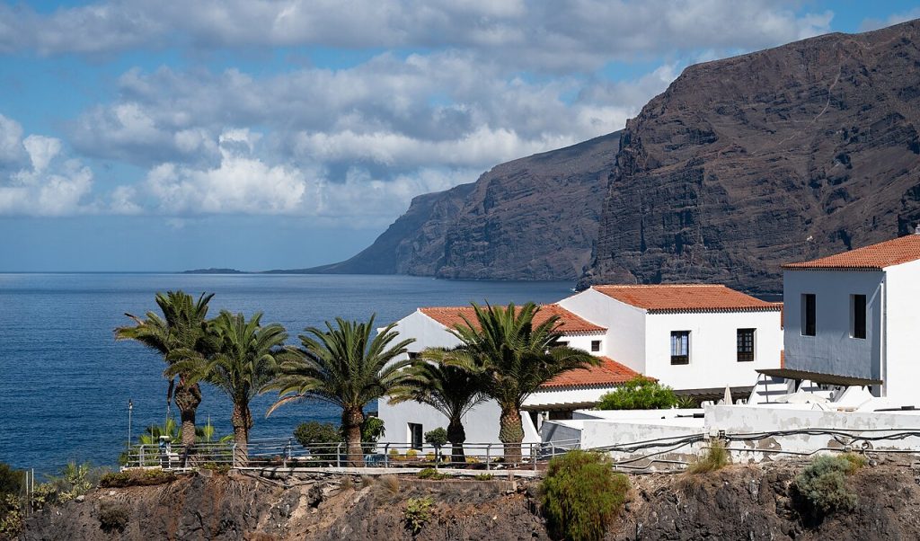
Insider Tip: The sunset view from the Mirador Archipenque is one of the finest on the island. The cliffs face west and catch the last light of the day in extraordinary colour. Time the drive to arrive at the viewpoint about 45 minutes before sunset. On very clear evenings the silhouette of La Gomera on the horizon with the sun dropping behind it is a genuinely special sight.
Food and Pit Stops: Drive 5
Playa de la Arena restaurants – the resort between Puerto de Santiago and Los Gigantes has a seafront promenade with good restaurants and a Blue Flag beach.
Mirador Archipenque cafe – serves coffee, cold drinks and light snacks with views directly down to Los Gigantes harbour and the cliff face.
Los Gigantes marina restaurants – fresh fish and seafood on the waterfront terrace facing the cliffs.
Total distance: approximately 30 kilometres from Santiago del Teide to Los Gigantes. Allow a half day or combine with Drive 2 for a full west coast day.
Tenerife UNESCO World Heritage Sites and Protected Areas
Teide National Park (Drive 1) was inscribed as a UNESCO World Heritage Site in 2007. Anaga Rural Park (Drive 3) holds UNESCO Biosphere Reserve status as one of the last remaining ancient laurel forests in the world. Driving within both requires staying on marked roads.
Frequently Asked Questions
How long does it take to drive around Tenerife?
The island is approximately 80 kilometres long and 45 kilometres wide. The full motorway loop takes about 2.5 hours without stops. A proper circuit including mountain and coastal detours takes two full days at a relaxed pace.
What is the best food to try in Tenerife?
Papas arrugadas with mojo sauce is the essential Canarian dish. Rabbit in salmorejo sauce and fresh Atlantic fish grilled over wood are the traditional main courses. The barraquito, a layered coffee drink with condensed milk, liqueur and cinnamon, is the signature Canarian coffee. Bienmesabe, an almond cream dessert, is excellent throughout the Canary Islands.
Are the roads in Tenerife suitable for all hire cars?
The motorways and main secondary roads are in excellent condition. The TF-436 Masca road and parts of the Anaga TF-12 require a confident driver. A smaller compact car is easier than a large SUV on the narrowest sections. All five drives are manageable in a standard hire car with care.
Do you need a hire car to explore Tenerife properly?
For the southern resorts and organised excursions, buses and taxis are adequate. For the Anaga forest, the Masca valley, Teide national park and the north coast colonial towns, a hire car is the only practical means of getting there on your own schedule. The five drives above require independent transport.
When is the best time to hire a car in Tenerife?
Tenerife has a year-round mild climate. May, June and September offer the best balance of good weather, lighter traffic on the mountain roads and competitive hire car pricing. July and August are the busiest and most expensive months.
The mountain drives are quieter in November to February, though Teide can occasionally be closed by snow at the summit.
Plan Your Tenerife Road Trip
Each of the five drives above can be completed as a standalone day out from any resort. Drives 1 and 3 make the strongest case for a full day. Drives 2 and 5 combine naturally as a west coast day. Drive 4 stands alone as the best introduction to traditional Canarian culture and food. Compare hire car deals across all Tenerife pickup locations on our car hire in Tenerife guide. Transparent pricing, no hidden fees and five drives genuinely worth making.
About the Author
Darryl Antonio is CEO of Digitalhound, a London-based digital marketing agency with over two decades of experience in SEO and content strategy. Darryl oversees digital strategy across all sectors the agency represents and manages content production and digital strategy for Getcarhire.com.